A Brief Geological History of Burlington
Written by Hayley Kolding and Charlotte Cadow
One billion years ago, the ground where we now stand was a violent and shifting land of collisions. Heat from our planet’s mantle dragged floating chunks of continental crust along in the whims of its currents, smashing them together with epic force. As the continents collided, they stuck together, forming a supercontinent with mountains rising up to mark its seams. One vast range of mountains rose up along the eastern edge of North America: the Grenville Mountains. Time has eroded them, but in their day, they were as tall and proud as the modern Himalayas.
What the earth puts together, the earth can also break. Over half a billion years of time and weather wore the Grenville Mountains down to their hard, crystalline roots. These small remnants would someday be pushed upwards to form just the caps of the Adirondack Mountains. Meanwhile, the continents began to wrench back apart. Piece by piece, chunk by chunk, they ripped away from the land that would become North America.
600 million years ago, North America itself began to tear apart. Like taffy stretched by invisible hands, the continental crust thinned and sank along new fault lines, forming rift valleys. Hot magma welled up from the earth’s mantle where the crust tore, cooling to igneous rock. Sand, mud, and gravel slid down the eroding remnants of the Grenville Mountains, landing in streams that carried the sediment into valleys opening below. This tumbling cargo, from the finest sands to the coarsest gravels, accumulated in the valleys as layers of sedimentary rock.
Who lived in this landscape? Who witnessed the clashing and tearing of continental crusts, the flowing and cooling of magma, the building of rock in raw new valleys? Few fossils remain from the times described so far. But we’ve reached a turning point in our story: a time when the rock we see exposed at Rock Point begins to form. A time when life bursts onto the scene.
A shallow sea had filled the rift valley between North America and Europe as it widened. The earth was warm at this time, the atmosphere was rich with carbon dioxide, and the sea–lit by the sun, close to the equator–exploded into life. There were tiny animals, and even tinier plankton and algae; trilobites; even early vertebrates that swam like miniature eels. When those creatures died, their hard skeletons drifted to the sea floor in layers that turned into calcareous limestone, then the smooth, tan dolostone cliffs that make up the hanging wall of Rock Point.
Around 500 million years ago, North America and Europe drifted back towards each other, squeezing the ocean between them from both sides. A chain of volcanic islands arose along our east coast. These massive volcanoes weighed down the ocean floor, creating depth where once had been a shallow sea. This was a tumultuous time in Earth’s history; a time of earthquakes and eruptions. Mudslides rushed down the underwater slopes of the islands, creating currents of silt and clay that traveled vast distances underwater before settling among the calcite skeletons on the ocean floor. Today, this ancient sludge has turned to the shale we see by the lake and under the cliffs: smooth, layered, gray rocks full of white veins, called Iberville Shale.
As the ocean continued to close, the island arc slowly ground into the coast. The force of the impact caused the rocks of the two land masses to fault and fold, to bend and break. The Green and Taconic Mountains grew skyward. At Rock Point, layers of rock were thrust upwards and westward on an angle such that the stratigraphy of the region, which once formed a bottom-up geological timeline in a vertical cross-section of the earth, now spreads itself horizontally over the shale like a deck of dealt cards. This is why the hanging wall of dolomite—a significantly older stone—now sits atop the younger shale as if dropped in place by some clumsy hand.
What followed the mountain-building and the thrust fault were 300 million years of calm. The mountains slowly eroded; sediments drifted into beds in the nearby ocean. Meanwhile, life was flourishing: fish ruled the oceans, developed legs and wandered onto land. Insects took flight. Seed plants evolved and grew to epic proportions.
Then, 200 million years ago, as flowers first bloomed, birds evolved, and dinosaurs walked where we stand, the ground began to shift once more. Europe pulled apart from North America, leaving new stretch marks on the land. The Champlain Valley. The Connecticut River Valley. Once again, magma oozed into the cracks.
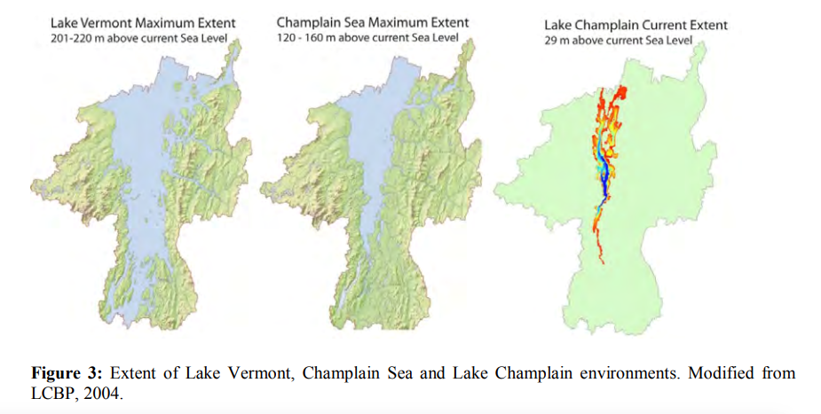
Let the cold air of winter move you forward from that time of magma to a time of ice. 18,000 years ago, a glacier covered Vermont, many miles thick. Small cooling and warming periods pushed and pulled the glacier across the land, scouring the bedrock below. As the glacier melted, it retreated northwards. Its meltwaters poured out the mess of sand and clay, pebbles and rocks, or glacial till, that blankets the hills of this region just below the grass.

The melting ice sheet also formed a lake. The cold, murky Glacial Lake Vermont was so deep that for thousands of years, all of Burlington was underwater.
Then, as the glacier retreated farther north, a passageway to the Atlantic Ocean opened up. Saltwater rushed in, replacing the glacial lake with the Champlain Sea. Meanwhile, the landscape — freed from the immense weight of the glacier — began to rebound upward. Eventually the bottom of the Champlain Sea rose above sea level, draining its brackish waters back into the Atlantic Ocean, and making way for the freshwater lake that we see at the base of these cliffs: Lake Champlain, the waters between.