Burlington Greenway Updates

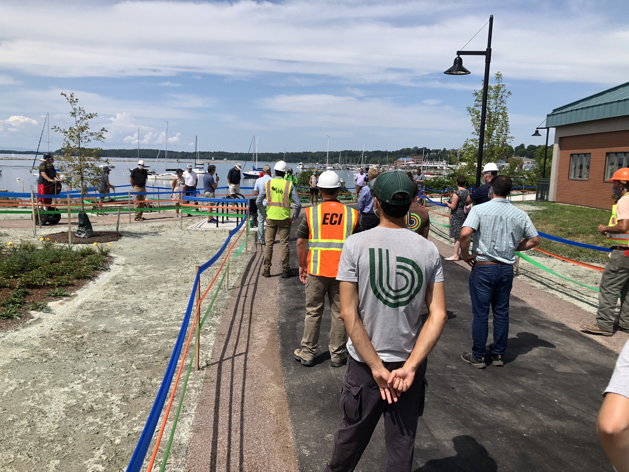
The Path is Open!
On December 8th, 2020 Mayor Miro Weinberger announced the opening of the Bike Path from Oakledge Park to Roundhouse Park, reconnecting the South End to the downtown. This completed section features significant improvements to path width and safety, and with its reopening, the City has now completed seven of the eight miles of the multi-year Bike Path rehabilitation project.
“Even as the City is focused on our response to the Covid-19 pandemic, we also continue to advance projects that ensure that we will be a stronger community on the other side of this,” said Mayor Miro Weinberger. “This re-opened section of the Bike Path is a dramatic improvement that will make it easier, safer, and more enjoyable for Burlingtonians to travel along the Bike Path from downtown to the South End. The Burlington Bike Path is both critical infrastructure and beloved part of the heart of our city, with this section, we’re continuing our work to restore, upgrade, and steward it for all Burlingtonians to enjoy.”
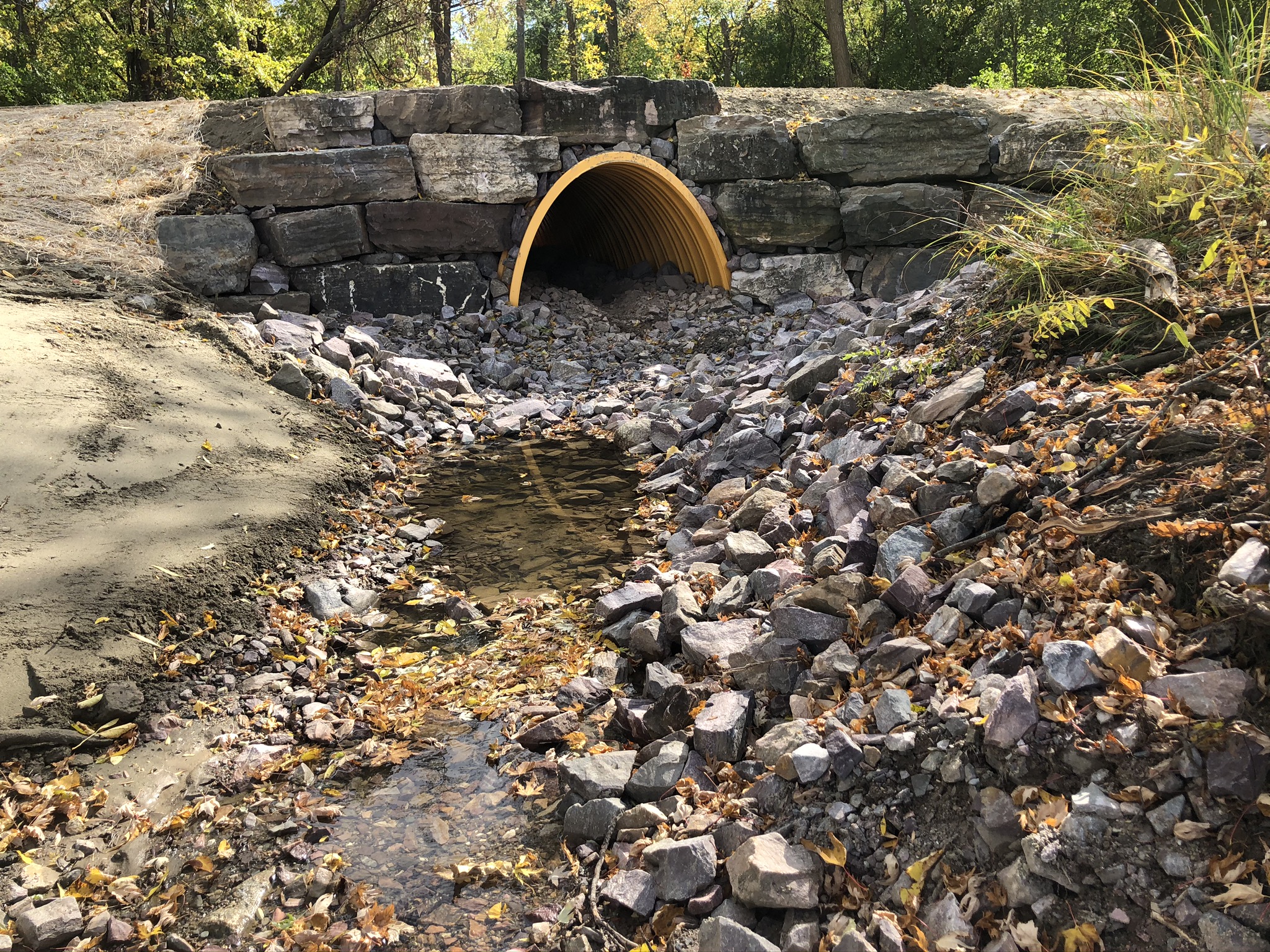
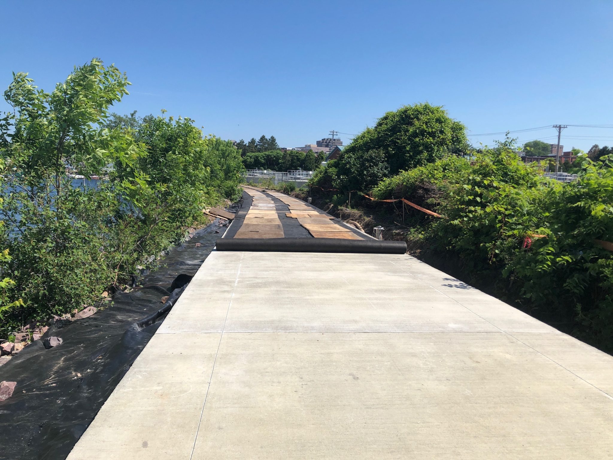
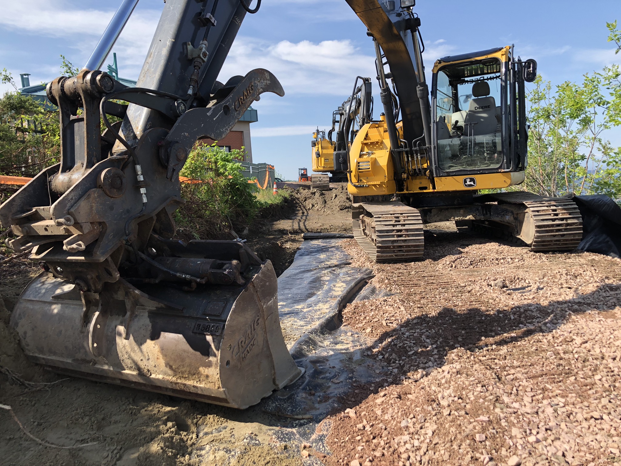
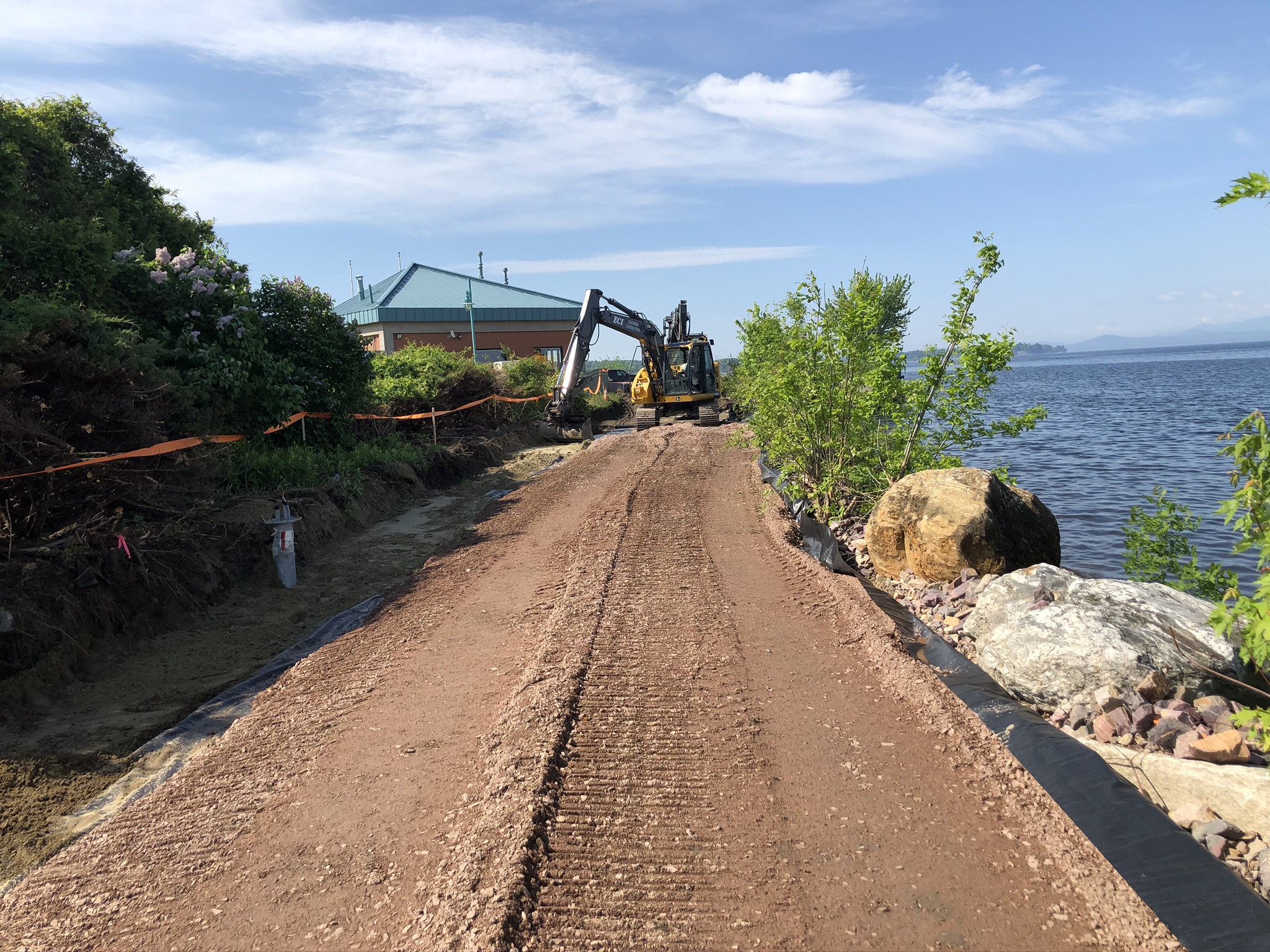
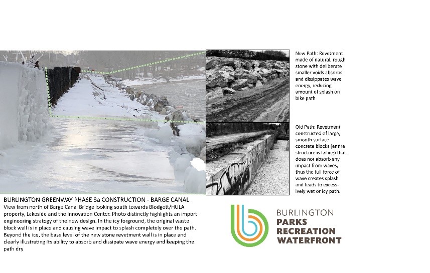
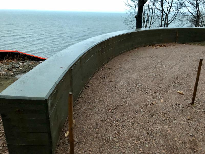
This section of the Bike Path crosses the Barge Canal in the South End, and improving it posed one of the greatest technical challenges of the entire path. In order to address the chronic problems of exposure to waves and wind, frequent deterioration, and crowding, the rehabilitation widened the path from a mere eight feet to the standard 15 feet of other sections of the Path. The rehabilitation also included creating a “revetment” wall alongside the path, built with boulders specifically designed to absorb wave action and prevent icing and wear on the path.
The reopening of this section follows a delay after the “Halloween Storm” of October 31, 2019 poured 3.3 inches of rain in Burlington, increased the level of Lake Champlain by two feet, and brought work on constructing the revetment to an abrupt halt, which prolonged a detour of the Path onto Pine Street. Fortunately, low levels of precipitation this winter and spring allowed the project team to progress quickly once they were able to restart work.
“The 1,000-foot stretch of Path along the Barge Canal was previously a narrow and occasionally treacherous section bombarded by waves, ice, blowing sand, and snow,” said Cindi Wight, Director of Burlington Parks, Recreation, and Waterfront. “Now, this section is completely rebuilt with accessibility, safety, resilience, increased recreation opportunities, and reduced maintenance costs in mind. Thank you to all of our many partners in this project, including federal agencies, State partners, land owners, City departments, and the designers and work crews who worked through challenging weather and the pandemic to bring this project to completion.”

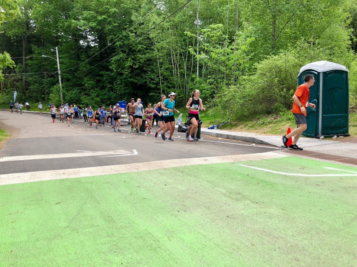
“I’m thrilled to see this section of the Greenway reopen, and very excited to make use of it in the 2021 Vermont City Marathon,” said Peter Delaney, Director of Run Vermont. “Most years, we chose to avoid these specific sections for safety reasons. Now, without hesitation, we can route our race through the most beautiful and striking sections of the Burlington Greenway.”
Throughout the Bike Path rehabilitation, the City has implemented improved standards that include safer alignment, extra width, accessible grade, smoother and more consistent paving, a shoulder for running and walking on both sides of the pavement, and pause places that create space for people to stop and enjoy. This latest phase is funded through the City’s Capital Budget, Penny for Parks, and philanthropic contributions from the Parks Foundation of Burlington.
Along with the Barge Canal, other improvements to this section have included, from north to south:
- A wider path with increased visibility and maneuverability from the HULA property to Lakeside Avenue, thanks to close collaboration with HULA;
- Connecting the Path to the sidewalk at Harrison Avenue and smoothing out grades at the intersection with the street;
- Paving a small section from the Oakledge bridge to Proctor Avenue, which links the Lakeside neighborhood with Oakledge Park; and
- Rebuilding the Path through the northern portion of Oakledge Park, widening this often-crowded part of the Path to the standard 15 feet and introducing inviting, expansive, and accessible seating areas with view across Lake Champlain.
The Bike Path is now open for use throughout its length, including the section from Perkins Pier into Oakledge Park.
Finishing the Rehabilitation of the Bike Path
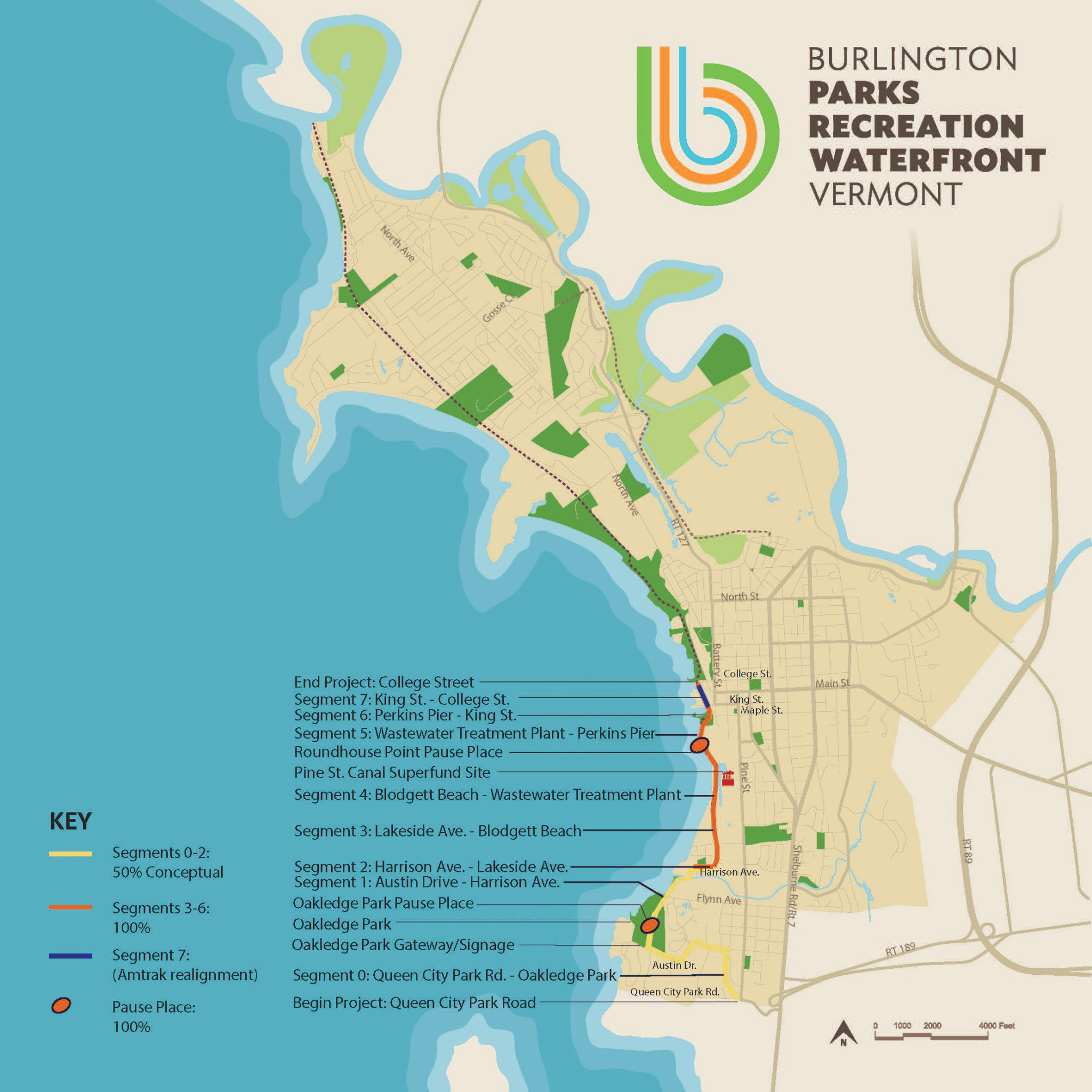
The reopening of this section of the Bike Path caps a year of work that included both off-road and on-road improvements from Queen City Park Road to Home Avenue, Proctor Place to Harrison Avenue, and through the Barge Canal and Roundhouse Park to Perkins Pier. This latest phase followed years of work to steward and upgrade the northern sections of the path from Perkins Pier north to the Winooski River Bridge.
Now, the City is working on Phase 3b of the Bike Path rehabilitation, which focuses on the Path through Oakledge Park. This work is expected to start in June 2021, and has been coordinated to allow maximum use of Blanchard Beach through the summer. The work will include improving beach access, realigning the path through Oakledge Park to meet Americans with Disabilities Act (ADA) standards, and improving circulation at Flynn Avenue. The project team is on track to complete the reconstruction of the entire eight miles of the Bike Path in the fall of 2021.
Background: Bike Path Rehabilitation Is Result of Years of Planning, Effort, and Generosity
The rehabilitation of the entire Burlington Bike Path is a multi-year project estimated to cost a total of $16.5 million. Phase 1a encompassed the segment from Perkins Pier to Penny Lane, and was completed in summer of 2015. Phase 1b picked up from Penny Lane, realigned the path through the Urban Reserve and added a new pause place, lookout, and three new UVM Medical Center Fitness Stations. Phase 2 covered just over 3 miles of full reconstruction from north of the North Beach overpass to the intersection of North Avenue Extension, and additional paving from North Avenue Extension to the Winooski River Bridge. Each phase has enhanced safety, ecological function, and connectivity, transforming the Bike Path into a linear system of parks.
The effort to rehabilitate the Burlington Bike Path began in 2010 with the convening of the Bike Path Task Force, which recommended a $12-16 million enhancement to bring the Bike Path up to modern standards. Following significant flood damage in April 2011, in November 2012, Burlington voters approved two significant ballot items put forward by Mayor Weinberger in his first months in office to fund the improvement and maintenance of the Bike Path, and also supported ongoing investment in infrastructure through Mayor Weinberger’s approximately $50 million Sustainable Infrastructure Plan in 2016, the most comprehensive infrastructure effort in modern Burlington history. Reinvestment in the Bike Path has also been made possible by the Parks Foundation of Burlington, which has raised over $1 million to supplement public investment in the Bike Path.
October Construction Update
September Update:
In like a lamb, out like a lion. The 2020 construction season got off to a slow start due to COVID-19 restrictions, but is poised to finish strong with four construction crews spread out over three projects from the north side of Oakledge Park to the recently re-opened Roundhouse Park to rehabilitated the Greenway. Weather and pandemic allowing, construction will be substantially complete and the long awaited re-opening of the South End section of Burlington’s waterfront multi-use path will occur as slated, in December.
Burlington Parks, Recreation and Waterfront (BPRW) has engaged contractors and resident engineers on two new projects since late August to complete Phase 3a South, from Harrison Avenue to the south end of the Barge Canal, and Phase 3b North, from Englesby Brook to Potash Creek (Blanchard Beach section) in the northern portion of Oakledge Park.

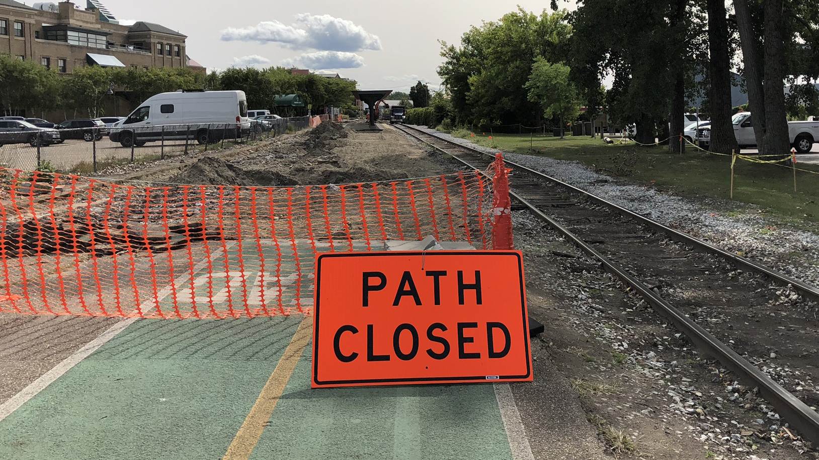
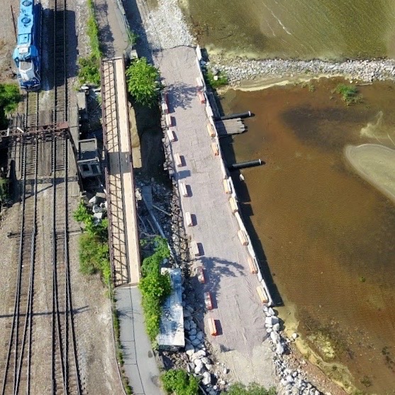
Additionally, Vermont Rail Systems (VRS) has begun work on their track realignment project between Maple and College Streets in preparation for the long-awaited arrival of the Amtrak passenger rail service. BPRW and Department of Public Works (DPW) are working closely with the Vermont Transportation Agency (VTrans) Rail Section and VRS on the design of that project when it comes to the realignment of the Greenway, more details soon.
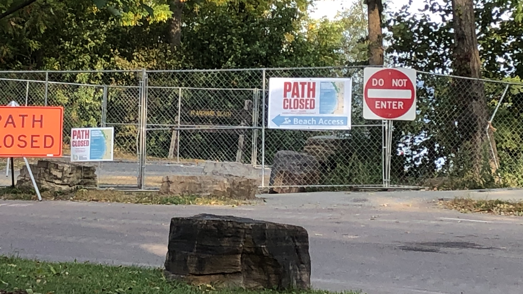
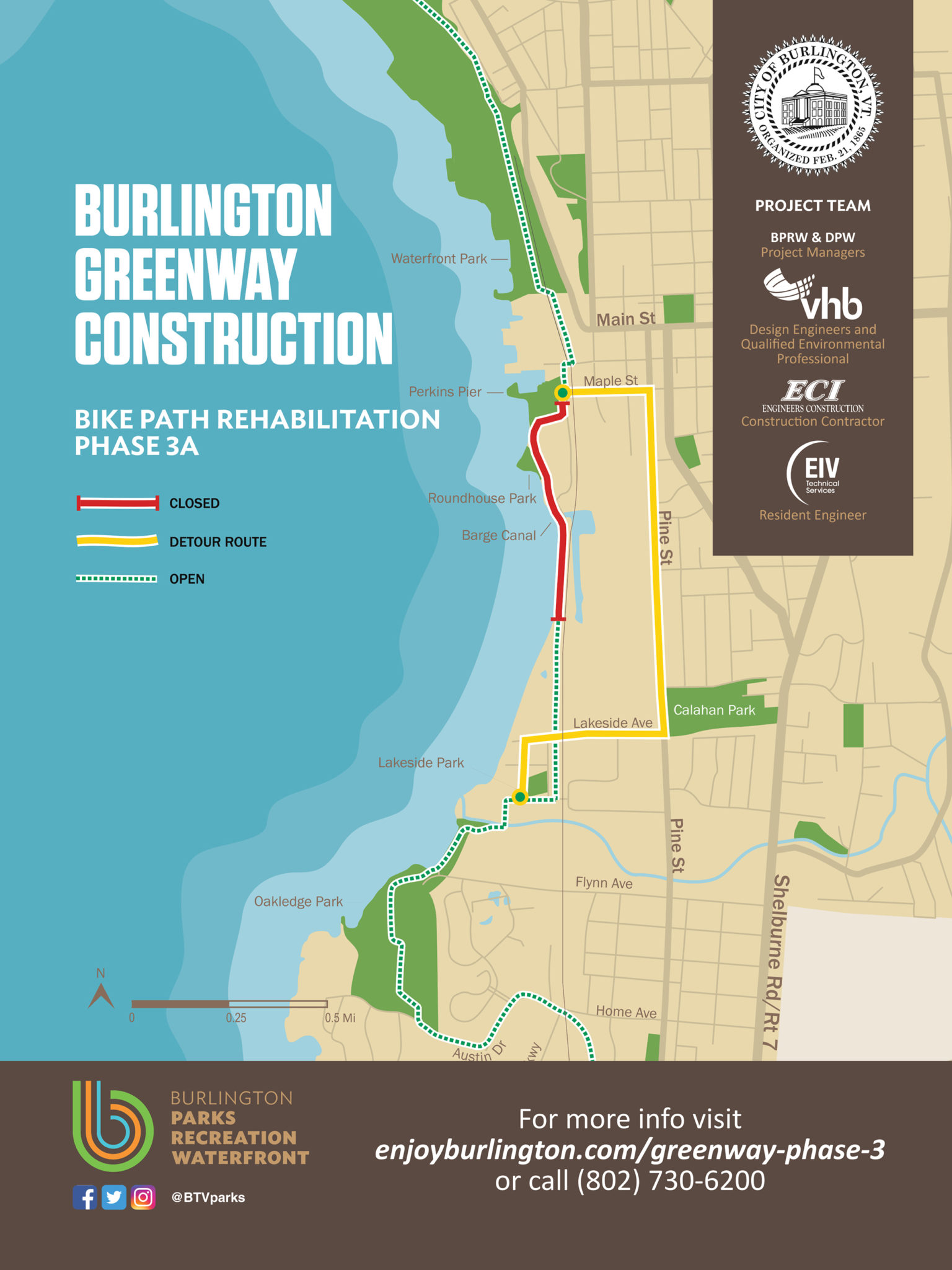
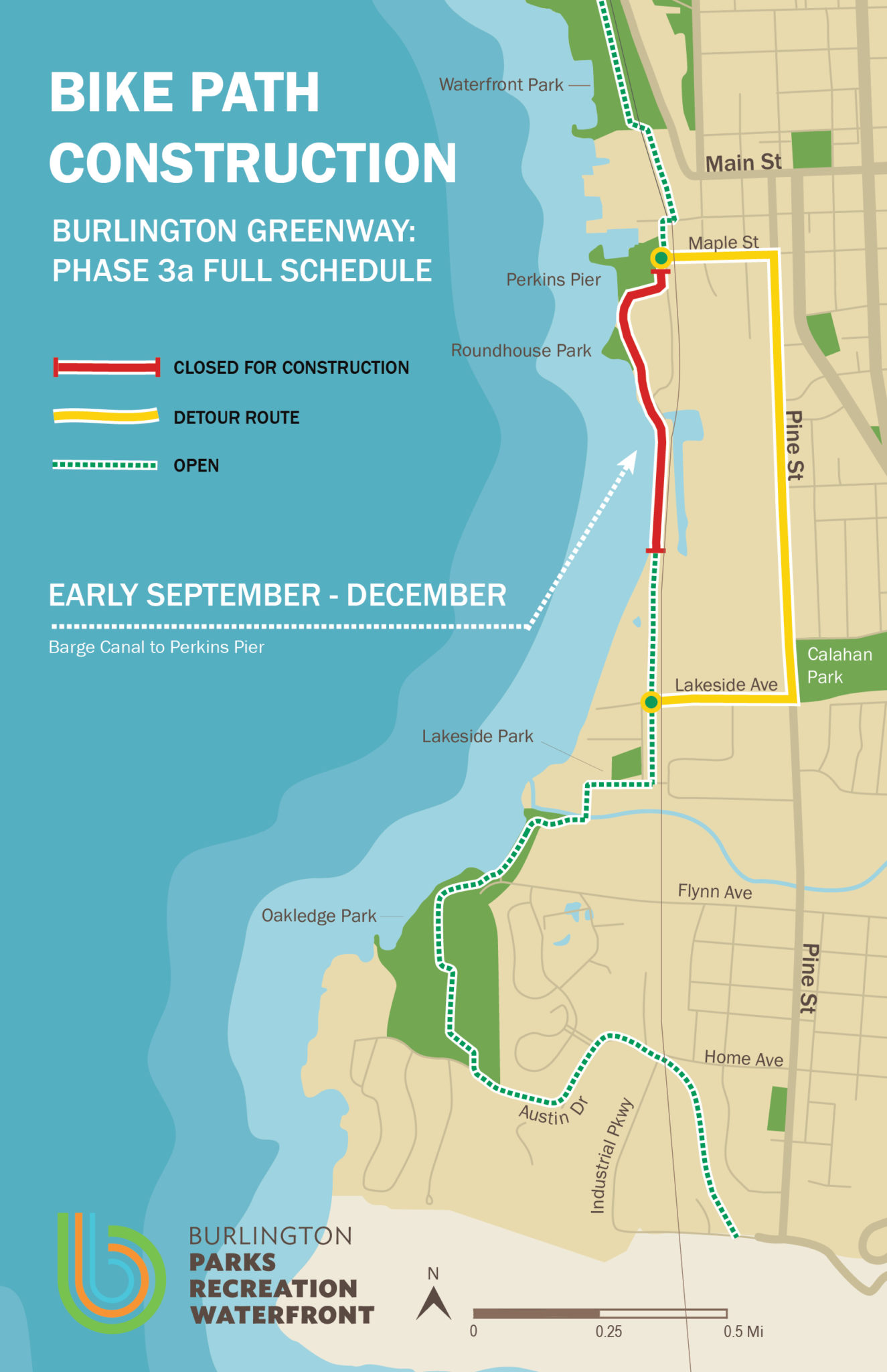
With all of this work happening concurrently, path users must detour between Oakledge and Waterfront Parks via Flynn Avenue, Pine Street, Maple Street, Battery Street, Main Street and College Street. While there are intermittent short sections of the path open between those two points (Perkins to Roundhouse Park, and Harrison to Proctor Place in the Lakeside neighborhood), it is not possible to travel between those locations.
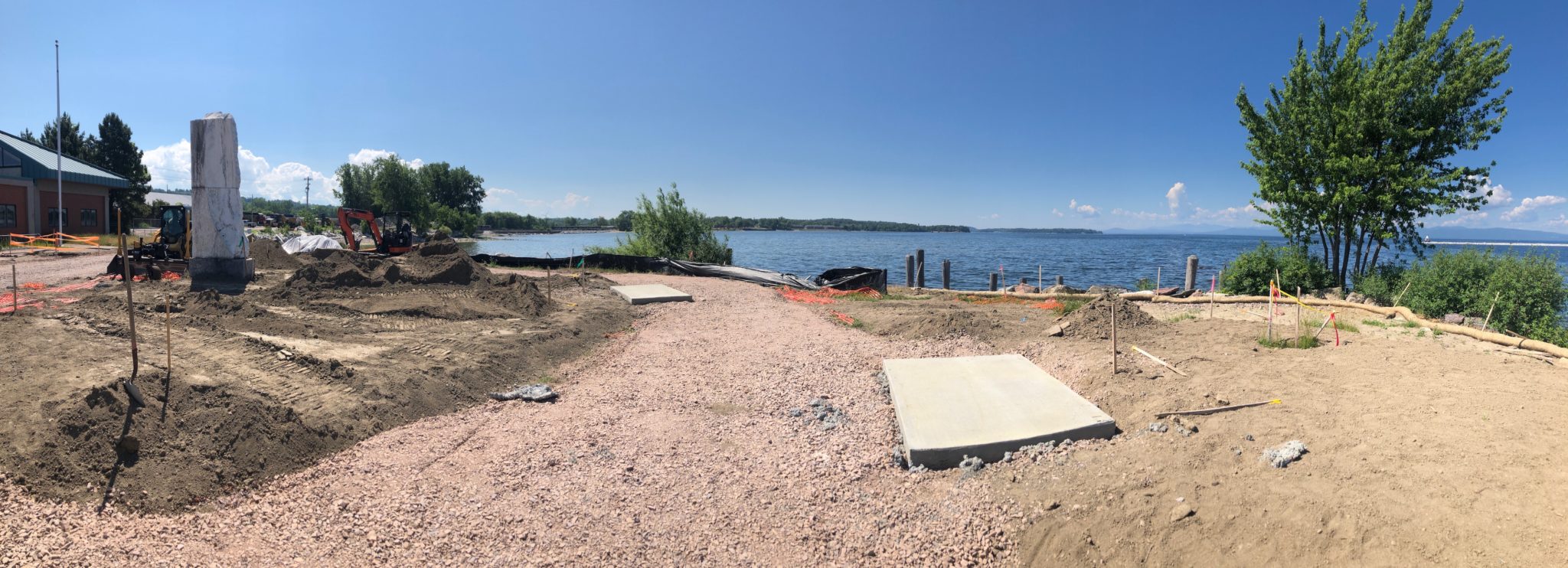
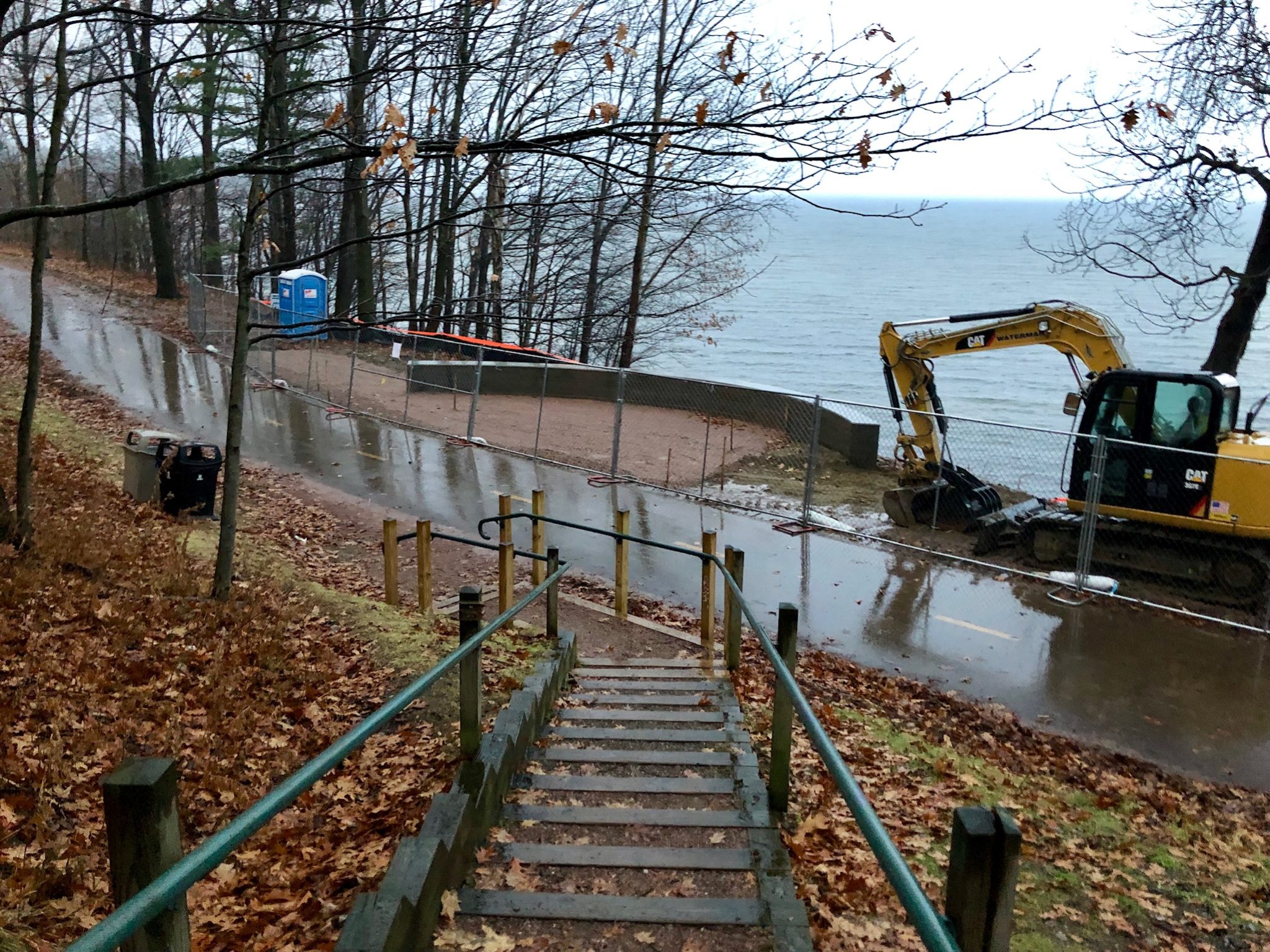
The mighty Barge Canal section is nearing completion and is scheduled for paving the last week in September, as is the short section between the Barge Canal Bridge and Roundhouse Park. Fence work, shoulder construction, line-striping and landscaping will follow to wrap up this project. BPRW will evaluate conditions before opening that short section up ahead of completion of sections further south. A reminder that all path users must obey signs, fencing and construction limits by staying out of the construction zones to allow workers to complete this work efficiently and safely. For questions about the work, please contact project manager, Jon Adams-Kollitz or check this project page frequently, rather than wander into a dangerous construction area.
We hope that many of you have had a chance to check out the newest highlights on the Burlington Greenway: Roundhouse Park and the Monolith (the concrete section of bike path in front of the Wastewater Treatment Plant). BPRW is proud to open these facilities to Burlingtonians and visitors during a time when parks and open space are more crucial than ever to enhancing the high quality of life in the Queen City.
August: Detour changes
The southern section of the Path will remain closed to traffic through the summer. Tentatively we expect to open some short sections in the later summer and fall, but travel down the Path over the Barge Canal portion will not be possible this summer.
Project timeline:
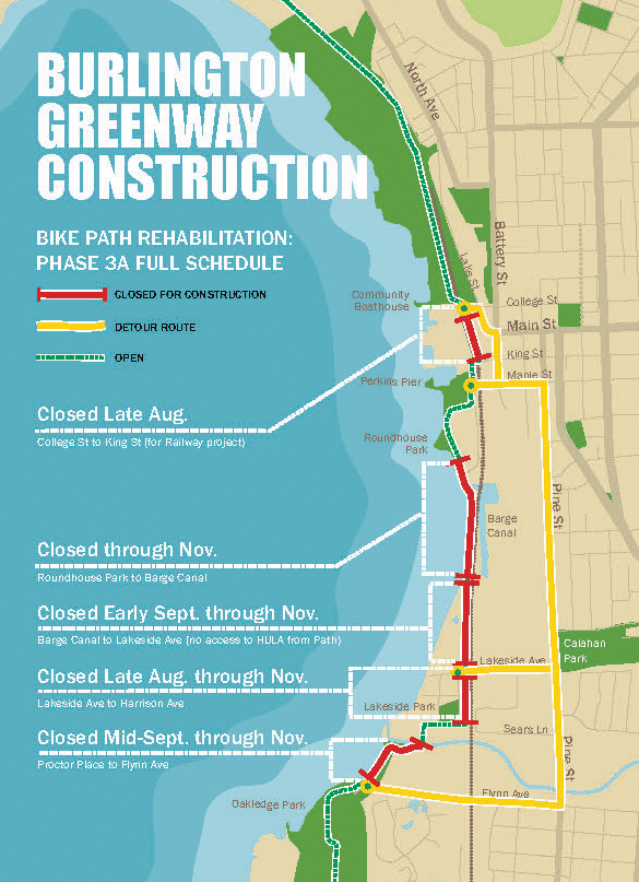
Phase 3a
- Roundhouse to Perkins Pier: re-opened August
- Barge Canal to Roundhouse: estimated re-opening November
- Lakeside Ave to Barge Canal: closed Mid-Sep through November
- Harrison to Lakeside Bridge: closed Late August to November
- Proctor Place to Flynn Ave: closing mid-Sept to November
View the interactive map
Additional Path Closures:
Access to the HULA property from Lakeside and Harrison will be closed Sept 8, as they finish work on their project.
Railway realignment between College and King will begin 8/24. We expect a full closure of that section by 8/31 for the duration of that project.
Reopening of the section between Perkins Pier and Roundhouse Park
From the official Press release: August 13, 2020
Mayor Miro Weinberger announced the opening of a new section of the Bike Path rehabilitation in the South End. This completed segment, which is between Perkins Pier and Roundhouse Park, comes as the City is on track to complete the rehabilitation of an additional 1.4 miles of the remaining 2.4 miles of the southern section of the path by the end of the calendar year, and follows years of work to steward and upgrade the path between Perkins Pier north to the Winooski River Bridge.
“Today we’re celebrating exciting momentum in our work to complete the rehabilitation of the entire 8 miles of the Burlington Bike Path,” said Mayor Miro Weinberger. “Roundhouse Park and a new stretch of Bike Path in the South End are now open and dramatically improved with benches, perennial plantings, and a path that will be much more resilient to exposure from Lake Champlain. At the same time, we are on track to complete the transformational rebuilding of the path through the Barge Canal, and bring an end to the detour onto Pine Street, this fall. I am grateful for our Parks team’s continued hard work to make this defining and treasured part of Burlington even better.”
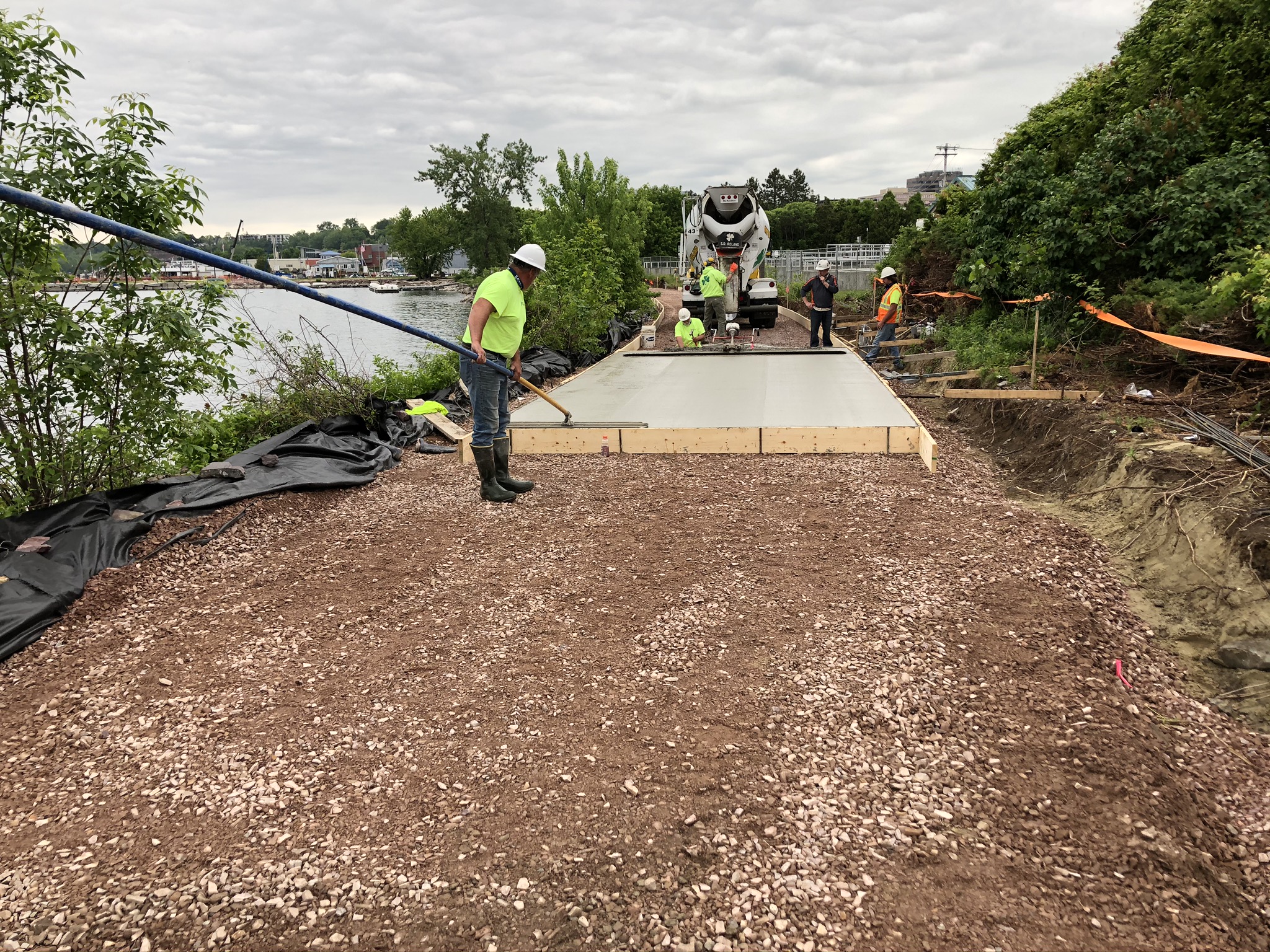
This completed segment hugs the shoreline and features some of the Bike Path’s most striking views of Lake Champlain and the Adirondacks – which also means that it has historically been one of the first portions of the path to flood during high water. The rehabilitated segment now features:
- A steel-reinforced concrete slab that will function both as the path itself and as a miniature sea wall to protect from wind and waves;
- Paving that will be better able to withstand water conditions and reduce the need for frequent and costly maintenance; and
- An increase in elevation by an average of one foot above the previous level, adding to the greater resilience of this section to high water.

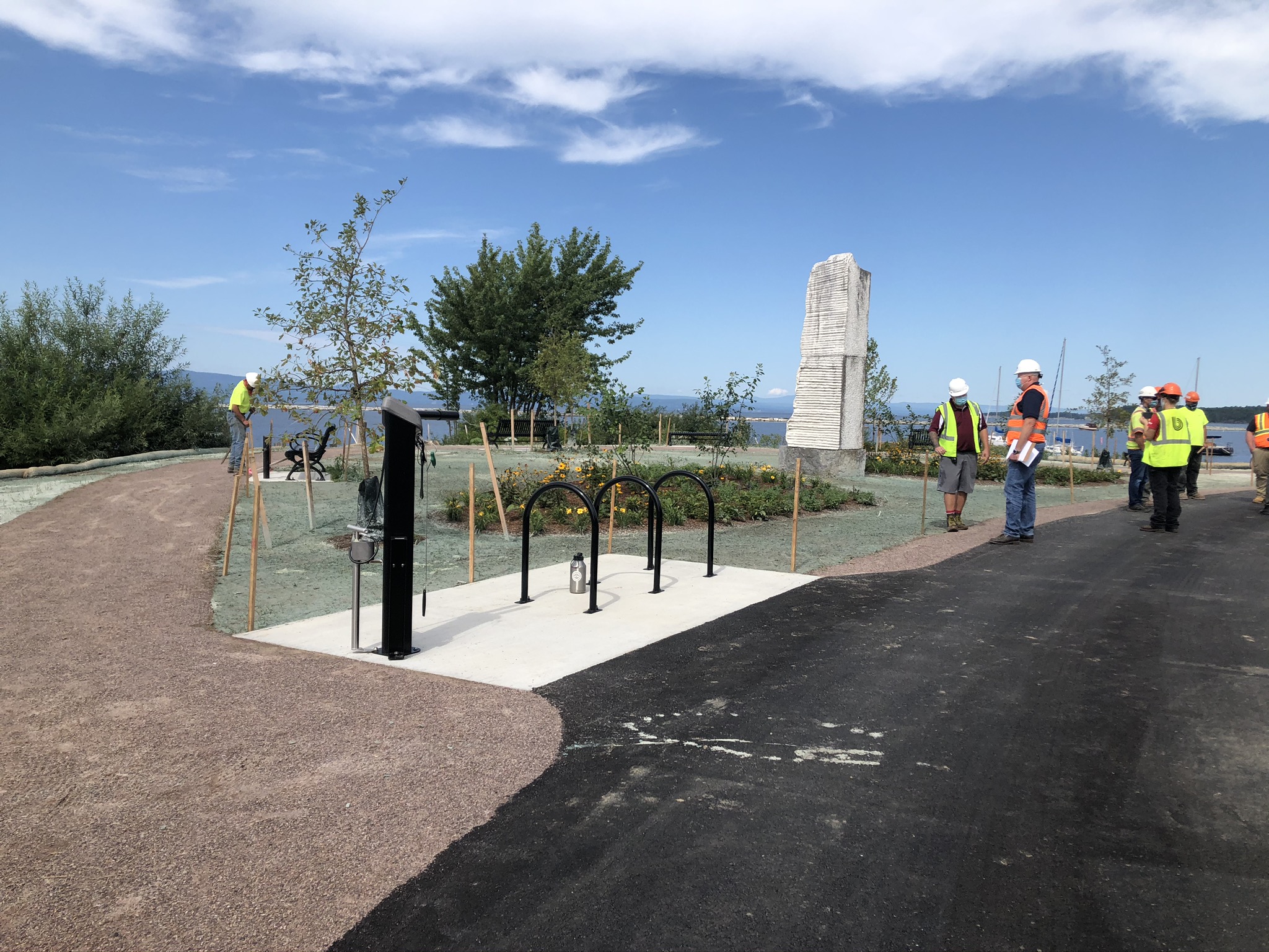
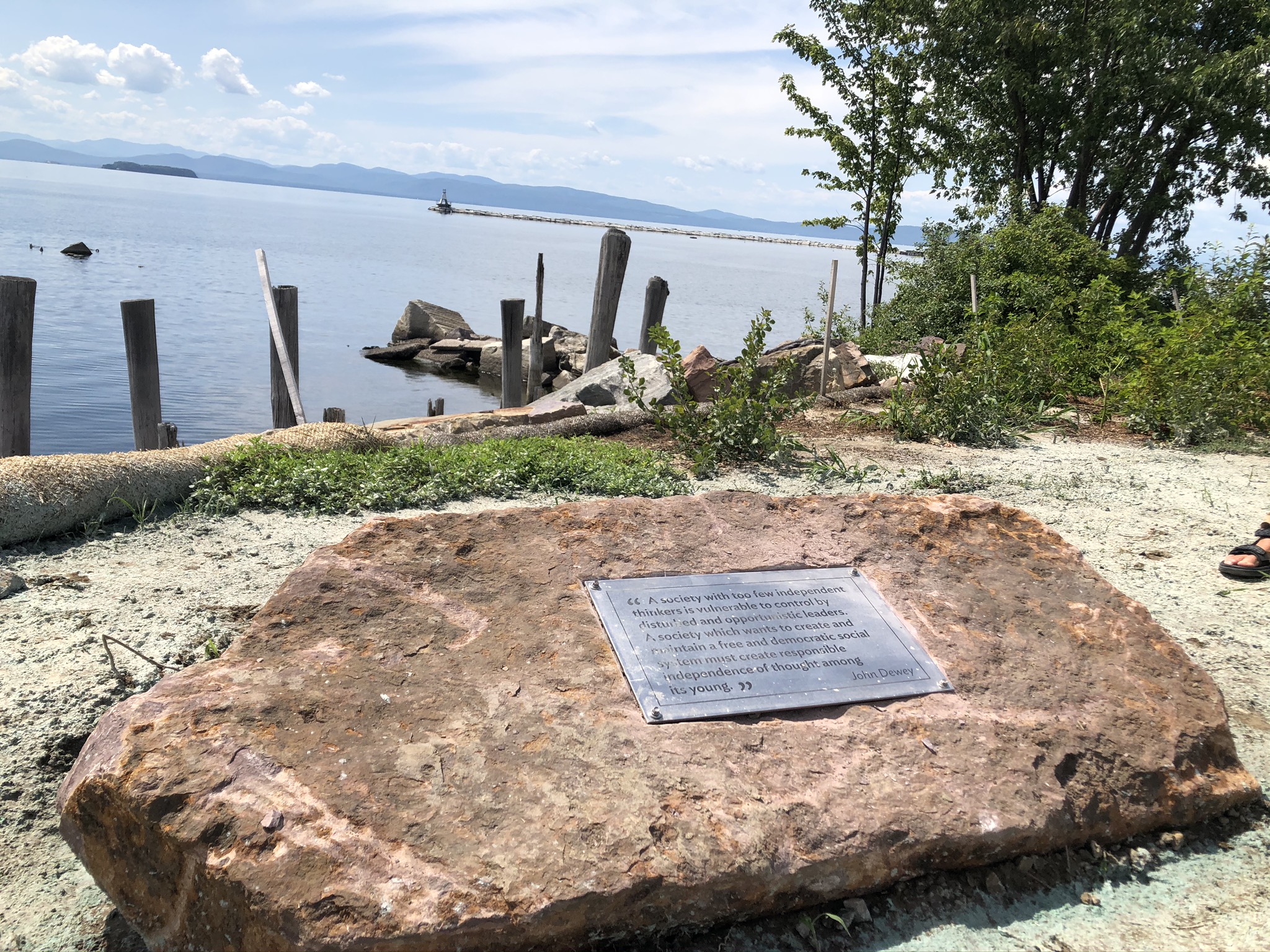
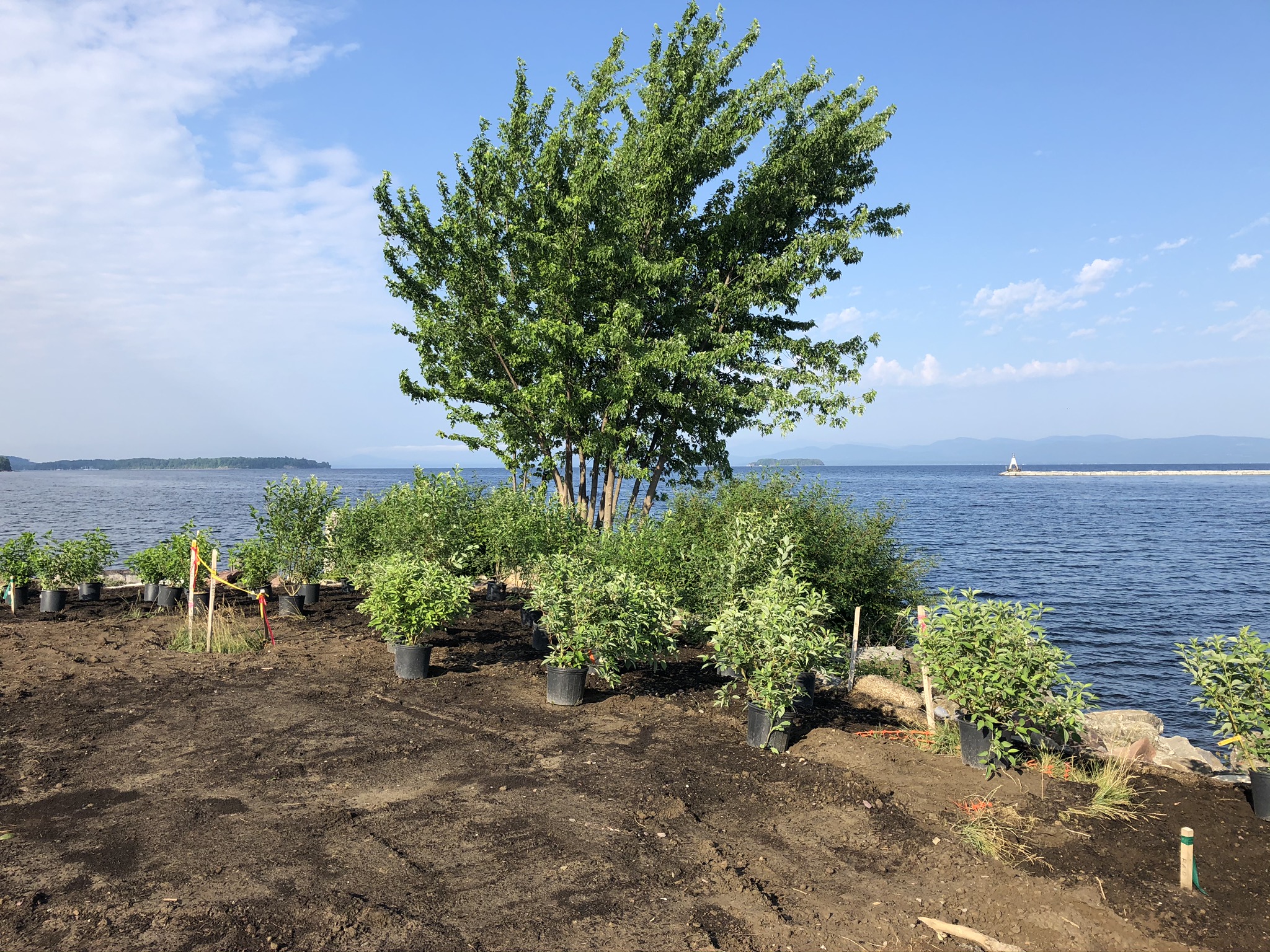
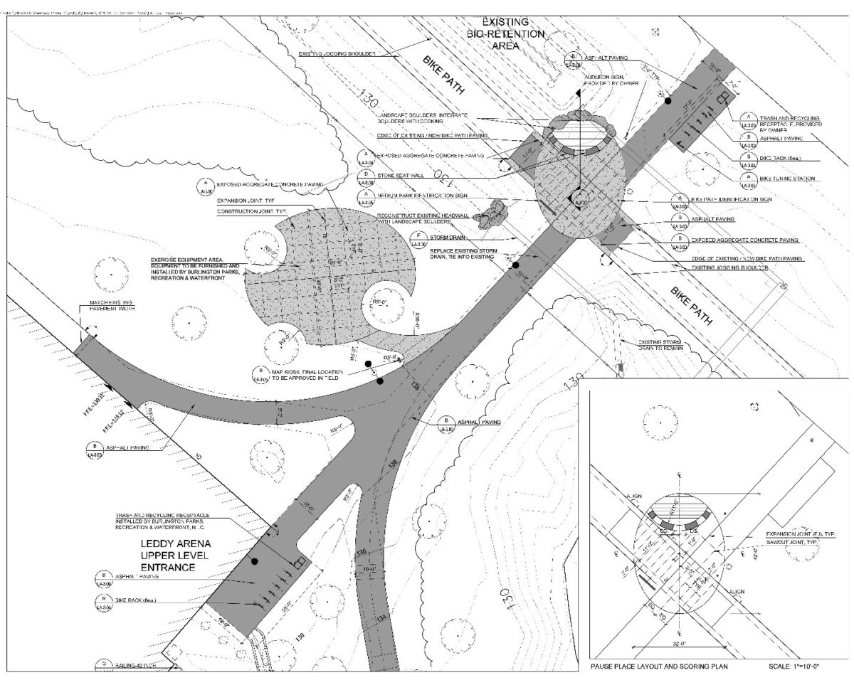
This segment also marks the opening of a new “pause place” at Roundhouse Park, featuring five new benches, a diverse array of trees and plants selected for their ability to thrive in the variable weather close to the Lake, colorful pollinator- and bird-friendly perennials, lighting, bike racks, and other features to make it possible for Burlingtonians to stop and enjoy this beautiful section of the Bike Path. This is the first pause place in the South End, and brings into the southern portion of the path a feature that has been widely embraced in the northern sections. This pause place is made possible thanks to a generous donation through the Parks Foundation in memory of Janet Bossange. Janet was a lifelong educator, artist, and dedicated volunteer throughout Burlington’s arts community.
“Like the other Bike Path pause places funded by the Parks Foundation, this wonderful point will now add another place for path users to pause and enjoy the magnificent view of our lake and the Adirondack Mountains, just as my late wife Janet would have wanted it,” said John Bossange, chair and founding member of the Parks Foundation of Burlington and longtime supporter of the Burlington Bike Path.
As work continues on the Bike Path to the south, currently, the only way to access this completed segment of the Bike Path is from the north via Perkins Pier.
Up Next for Bike Path Rehabilitation in the South End
This segment is part of Phase 3a of the rehabilitation of the Burlington Bike Path, and work on the remainder of this phase is ongoing. It includes both off-road and on-road improvements from Queen City Park Road to Home Avenue, Proctor Place to Harrison Avenue, and throughout the Barge Canal to Perkins Pier.
Phase 3a also includes the section of the Bike Path that crosses the Barge Canal, which is one of the most technically challenging sections of the entire 8-mile path. The work on this section includes constructing a “revetment” wall in the Lake itself to mitigate wave action on the path, which requires low water levels to construct. On October 31, 2019, the “Halloween Storm” dumped 3.3 inches of rain in Burlington, increased the level of Lake Champlain by two feet, and brought work on this section of the path to an abrupt halt.
Fortunately, the low levels of precipitation this winter and spring have made for strong progress in this section. The construction team is on track to finish the section of the Bike Path through the Barge Canal this fall. When complete, this section will be greatly improved from its previous condition, including through a sloped revetment that will protect the path from the Lake and stop the rapid deterioration that previously plagued this section, and an expanded width from 8 feet to the full 15 feet of other sections of the path.
By the end of this calendar year, the team also will begin and complete work between Harrison Avenue and the Barge Canal, reconnecting this critical section of the Bike Path from the Lakeside neighborhood to the central waterfront. Work also is expected to begin this fall between Blanchard Beach and Proctor Place.
Throughout Phase 3a, the City is implementing the same standards as it has in the northern section of the path, with safer alignment, extra width, accessible grade, smoother and more consistent paving, a shoulder for running and walking on both sides of the pavement, and pause places that create space for people to stop and enjoy. Phase 3a is funded through the Capital Budget, Penny for Parks, and philanthropic contributions from the Parks Foundation of Burlington.
“The Greenway is more than just a bike path,” said Cindi Wight, Director of Burlington Parks, Recreation & Waterfront. “It provides an accessible route along the length of our city. It is safe for families, for our seniors and provides a much-needed, off-road, year-round transportation corridor. It connects seven parks in the city along the route, and is of itself a linear park.”
Late June Update
Barge Canal, Here We Come… Again!
Our contractor is staging a swift return to the Barge Canal section of the Burlington Greenway, where they made a hasty exit after the Halloween Storm of last year. The low-snow winter and mostly warm and dry conditions of spring and early summer providing adequately low lake levels combined with timely permission from our permitting friends at the State of Vermont Department of Environmental Conservation, crews are able to get re-started on this key piece of the Path. Crews have been working steadily on rehabilitating the section behind the Waste Water Treatment Plant and Roundhouse Point for the last few weeks. We plan to open the section at Roundhouse Park open by the end of July! Currently the Path is open from Harrison Ave to the sandy area south of the Barge Canal bridge. It’s a great spot for watching the construction action.
Work on this phase and the remainder of 3a North is expected to be wrapped up in the fall. We will be opening access to sections north of the Barge Canal as they are completed. The entirety of the Greenway should be open for a few weeks before work begins on the Harrison Ave to Barge Canal section (3a South). That work is expected to take up most of the fall. BPRW also is aiming to rehabilitate the northern portion of the path in Oakledge Park between Blanchard Beach and Proctor Place in late fall.

Mid-June Update
Phase 3a of the Burlington Greenway Rehabilitation has resumed following a delayed and measured start due to the State COVID-19 restrictions. Work at Perkins Pier, which focused on safety and accessibility driven repairs to the walkway network was completed on schedule and opened to the public on May 15, just in time to add more open space for socially distanced recreation and relaxation.
As COVID-19 restrictions were relaxed by the State, crews moved to the stretch of path along the wastewater treatment plant, Roundhouse Point and towards the barge canal. Despite its many complexities, this section is well underway and slated to be open to the public in early July.
As one of the more highly engineered sections of the path and the most prone to flooding, the new innovative and ambitious re-design will ensure this section will remain usable in all but the most extreme high water, wave and ice conditions. At the core of this section’s strength is a massive concrete slab, 475’ of 9” steel reinforced concrete, over 9000 tons of material designed to act both as a sea wall and path surface.
This protective engineering begins near the northwest corner of the waste water treatment plant and will minimize the potential degradation to the path caused by the relentless wave and ice damage. Additionally the section has been raised by an average of 1 foot above his previous level first minimizing the impact during highwater.
At Roundhouse point, park users will be treated to a completely revamped mini park. Landscaped with a diverse array of largely native trees, shrubs and colorful pollinator and bird friendly perennials – this location will feature many new benches with spectacular views across the lake and a much more resilient shoreline
Summer Detour
This section of the Path will remain closed to traffic through the summer. Tentatively we expect to open some short sections later this year, but travel down the Path over the Barge Canal portion will not be possible in 2020.
- Roundhouse to Perkins Pier: estimated re-opening August 2020
- Barge Canal to Roundhouse: estimated re-opening November 2020
May Update
Good news! Work commenced in early May and crews got right to work. As of May 15th Perkins Pier is reopened!
Repair and repaving work that began at that location last December is complete.
Highlights include:
- Substantial reduction in impervious surfaces
- Improvements to accessibility and safety
- Better access to the Lake Champlain Maritime Museum Lois McClure (when she’s docked there)
Please stay off newly seeded areas behind orange snow fence.
Repairs are nice, but they are technically a short-term fix until the site can get go through a thorough master planning process.
As work continues to the south, the contractor focused on the path adjacent to wastewater treatment plant and is now working on the mini park at Roundhouse Point.
2020 Spring Update (March)
Construction Work Is On Hold
Design & Planning Work Continues
Future Plans
2019 Recap
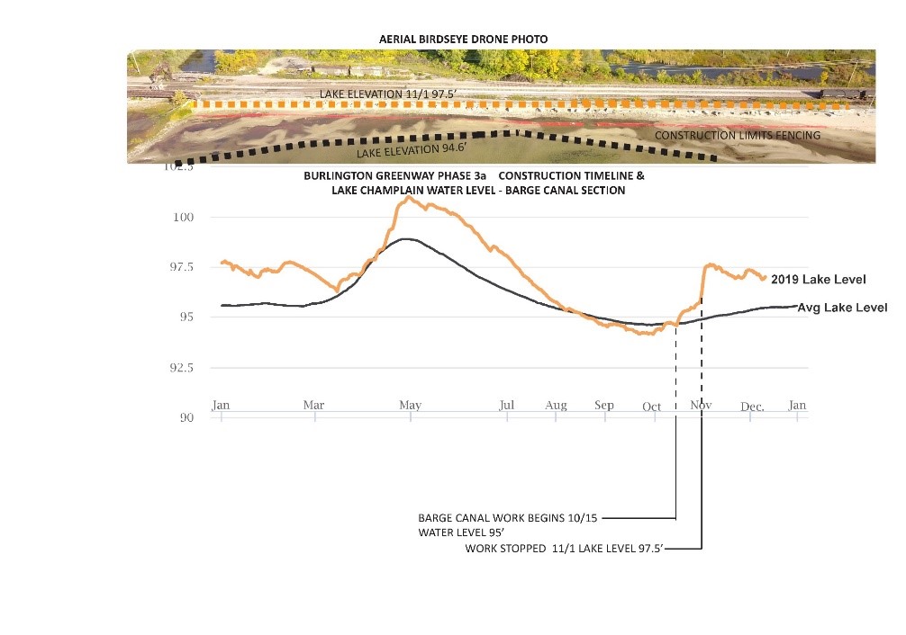
This fall, Burlington Parks, Recreation & Waterfront (BPRW) began work on one of our most technically challenging sections yet of the entire 8-mile Greenway: the 1,000 feet of path where the Greenway crosses the Barge Canal in the South End. This area has long been a pinch point, and the plan for rehabilitation will make this section substantially better, bringing it to the full width of the rest of the Greenway and constructing a “revetment” wall to mitigate wave action and reduce winter icing. The work on this section requires us to be in the Lake itself, and that requires the type of low water levels that Burlington typically experiences in the fall and winter.
This year, though, we had the “Halloween Storm.” On October 31, 2019, this storm dumped an astonishing 3.3 inches of rain down on Burlington in a matter of hours. As a result, the level of Lake Champlain rose by multiple feet. The day after the storm, we had to bring construction along this section of the Greenway to an abrupt halt, and the water levels have remained persistently, unseasonably high since then. Unfortunately, we will not be able to complete the work in this section until water levels drop again, which is expected to be late summer or early fall of 2020. This means that the section of the Greenway from Lakeside Avenue to Maple Street will have to remain closed for the remainder of 2020. While we are disappointed to not be able to re-open this section of the Greenway sooner, we are looking forward to the substantial improvement that will be here when this work is complete.
Much more information is included in the update below.
Halloween Storm Brings All Tricks, No Treats
The section of the Greenway that crosses the Barge Canal represents the most technically challenging section of the entire path. These 1,000 feet of Greenway are sandwiched between the railroad tracks, a failing concrete waste block wall, a railing that needs constant repair, a pressure-treated extension, and Lake Champlain. On the other side of the rail right-of-way is the Pine Street Canal EPA Superfund site. Regular users of this section of the Greenway know that it is often a pinch point and can be dangerously exposed to the Lake’s wind and waves, especially in the winter, when its current design promotes substantial icing along the path. Additionally, this section is currently too narrow for BPRW to provide the standard level of maintenance that the rehabilitated portions of the Greenway receive.
The plan for rehabilitation will change all of this. The Phase 3a Greenway construction will expand the current Greenway width and design standards through the entire path, including this tricky section. And here’s the good news: We can already see evidence that the intense engineering effort required to improve this section is working. In the section that we were able to construct before the Halloween Storm hit – with a rebuilt slope and a wall of large, erratic boulders to absorb and dissipate wave energy – the path is now dry and largely ice-free. In the section of the path where we haven’t yet constructed the improvements, in contrast, there is significant wave action and ice buildup on the path.
We started construction in mid-October of 2019, following the completion of a complex permitting process with the U.S. Army Corps of engineers and the State of Vermont Department of Environmental Conservation to allow the Greenway to be widened into the Lake. At that time, though a series of storm events in early October had already pushed up lake levels, conditions along the Barge Canal were still ideal. In a typical year for water levels, we would have been able to re-open this section by spring of 2020. Our contractor staged thousands of tons of rock and other materials on site, and made highly efficient progress.
Then, on Halloween, the storm pushed the lake levels a total of two feet higher than they were when work was started on this section. The morning after the storm, it was all tricks and no treats, as our contractor scrambled with the excavator in the water to try to do as much as possible to stabilize the site. The water kept rising, and with the onset of colder temperatures, most of the work zone was eventually covered in a sheet of ice.
On November 6, the lake elevation topped out close to 98;’ feet – compared with 95 feet, the average level for Lake Champlain in a typical year in the fall. Our contractor had constructed a temporary “swamp mat” bridge made out of railway tie-sized timbers, and at that point, it began to float, and was the last item removed as the crew worked their way out of the exposed site.
As a result of all of this, the Halloween Storm brought construction season at the Barge Canal to an end – months earlier than is typical, than our work schedule had anticipated. Based on permitting, water levels in Lake Champlain need to return to 95 -96 feet before construction can resume. Unfortunately, this is not likely to occur until after spring snow melts and rains subside within the Lake Champlain Basin. Reduced water levels are thus unlikely to occur before fall of 2020 – meaning that the Greenway through this section will be closed to all users until at least the end of 2020.
We are disappointed that this atypical weather event has altered the schedule of this part of the Greenway rehabilitation. At the same time, we remain excited about how this project will improve the year-round safety and accessibility of this section of the bike path, and by extension, of the entire Greenway.
We appreciate your understanding and patience. We hope bikers and path users will see 2020 as the year to embrace the detour along Pine Street, and all of the vibrant culture that the street offers. As soon as conditions allow, BPRW and our project team will mobilize to take advantage of any workable window that nature offers.
Emphasizing Resiliency beyond the Barge Canal
The stretch from the Barge Canal to Perkins Pier is historically heavily impacted by wave action. The Burlington Harbor Breakwater protects much of the central waterfront, but strong winds from the southwest are able to bypass the breakwater and hammer the shoreline in these locations. Although some of the shoreline was repaired with funding from FEMA in 2012, many portions of the shoreline needed to be reinforced and better protected from erosive degradation. Our contractor prepared for the more intensive and risky work in the Barge Canal area by implementing reinforced shoreline repair in much of this area while awaiting final permitting go-ahead on the barge canal.
Further to the north lies the lowest (and most flood-prone) portion of the Greenway between the Wastewater Plant and Perkins Pier. This section will be raised in elevation and receive a custom designed reinforced concrete shoulder that will function as a mini seawall. While these engineering approaches will not make this stretch completely flood and wave proof, they should significantly reduce the bike path maintenance costs in this area, which has historically been a hotspot for maintenance and repairs, and the number of days per year this section is closed or requires detours. This section will be one of the last portions of the bike path rehabilitation phase 3A to be completed, as our contractors work their way out of the project from south to north.
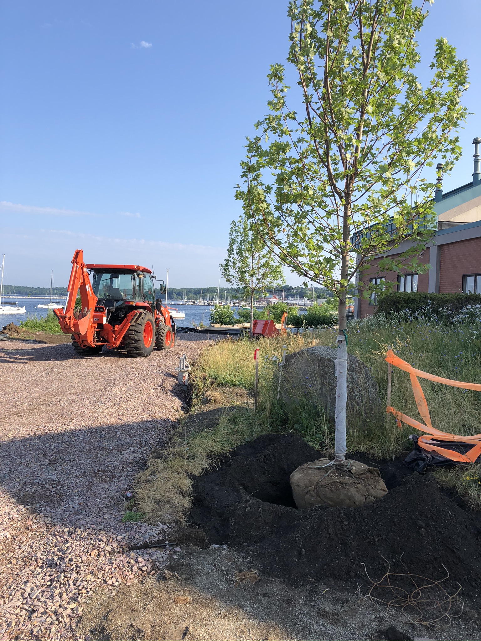
The northern portions of Phase 3a (Roundhouse, Wastewater, Perkins Pier) are areas in addition to the barge canal most prone to erratic and severe rain and wind, events that are becoming more common with climate change. This area was also planted with an almost monoculture of ash trees, making it especially vulnerable to the imminent arrival of the Emerald Ash Borer (EAB). As has become standard on BPRW construction projects, we are including ash removal within the project limits, which will lower our costs and workload when the disease spreads across the city, and may help to slow its spread. Our standard is to replace the removed trees with a diverse array of native and cultivated native trees, a more resilient approach to planting. In scenarios of pest infestation and erratic climate trends, a diverse stand of trees, with other smaller plantings, is less likely to be decimated by insects, disease, drought, heat, wind, or cold temperatures.
This approach will be evident when Roundhouse Park reopens, where we will plant four species of canopy trees that emphasize fall color and winter interest, including native species that are adapted to the harsh conditions of Lake Champlain’s waterfront. Additionally, there will be more site amenities, including benches and bike racks, located in two different areas of the park. This mini-park or pause place is also one of several bike path amenities prioritized for funding support by the Burlington Parks Commission.
Other resiliency-driven design changes in the vicinity include closing a short section of old alignment just north of the Barge Canal (wooden) bridge and, instead, formalizing a longstanding goat path that provides a straighter, safer, and shorter pathway though this section. The new path will pass through a declining collection of Austrian pines and the old alignment will be turned into a heavily planted berm.
In the meantime, the Barge Canal section (as well as adjacent stretches of the path) have also been omitted from the BPRW winter maintenance procedure, referred to as ‘Ski to the East,’ that involves keeping the west half of the full width sections of the Greenway plowed for pedestrians and bicyclists while maintaining snow cover on the east half of the path for skiers and other snow enthusiasts. When completed, the full width path adjacent to the Barge Canal will receive the new, best of both world winter maintenance. Even in the most benign weather conditions, the narrow path hemmed in by fencing on both sides was always a challenging section during the busiest months of path use as well as a section detoured during some of the Greenway’s signature events, like the Vermont City Marathon.
See you next spring!
December Update

 |
| Get a behind-the-scenes view of what was happening, until the water levels rose. |
September Update

 |
| Burlington Greenway Rehabilitation – Proctor Place |


Mid-September Detour Changes
Work has begin on the next section. The path remains closed between the Barge Canal and Roundhouse Park (near the water treatment plant). So the detour route is from Lakeside to Maple st.
Mid-August update:
Revised update 8/27
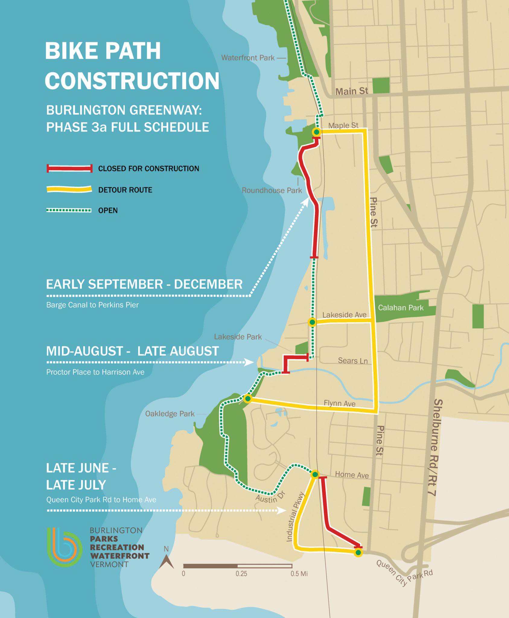
Apologies for any confusion about the the path closure last week. In order to minimize interference, the crews held off closing the segment until work was fully ready to mobilize. That is happening now. The path will be closed at Procter Place starting today, August 27th at approximately 2pm. The detour route from Flynn to Maple should be used.
Detour Begins on Southern Section of Burlington Greenway on Thursday, August 22, 2019
Greenway users be aware that beginning on Thursday, August 22 the Greenway will be closed to all traffic from Flynn Ave to Maple St. to allow for contractors to work in the Lakeside neighborhood portion of the Greenway on Proctor Place and Harrison Ave. Users will be able to access the path in Oakledge park, but it will be closed at the bridge over the brook. This work is scheduled to be completed in three weeks. After that, crews will head further north to Perkins Pier and the Roundhouse section. Stay tuned for further updates. See map below for detour route.
Simultaneously, the elusive Segment 0 will open to the public. This section has received a major upgrade and, for the most part, has been brought up to our current standards and very intuitively to the on street portion of the Greenway on Austin Drive, which was recently improved by Public Works. HAPPY RIDING ON THE 0!

July 19 update: Construction moves to the Lakeside neighborhood July 29th.
BPRW’s contractor will be mobilizing to the Lakeside neighborhood portion of the Burlington Greenway at the end of the month. Work is expected to be completed by mid to late July, weather permitting. Improvements include the reconstruction of an 18’ paved residential street (Proctor Place from Oakledge to Harrison Ave) with partial curbing, new asphalt surfacing, full depth sub-base, improved drainage, pavement markings and signage. This will be a no parking street and will be an improved connection to the on-street portion of the Greenway. Harrison Ave will receive new pavement markings to improve safety and wayfinding.
The detour for this section starts at Oakledge Park’s main entrance, heads east on Flynn Ave., north on Pine St, and west on Maple St. back to the Greenway. Please obey all signs and traffic rules. At intersections, bicyclists may wish to walk their bikes as pedestrians using walk signals and crosswalks.
Segment 0—the practically secret section of the Greenway between the city’s southern border at Queen City Park Rd. and Home Ave—is almost completed and it will be spectacular! Improvements will include widening the paved bikeway, new pavement markings, 2’ aggregate shoulders for runners/walkers, and full compliance with the American’s with Disabilities Act (the initial slope from Home Ave. to the south has been made less steep, dropped from 9% to about 4%).
Upon completion of the Proctor and Harrison, contractors will move to the Barge Canal, Roundhouse Point and Perkins Pier sections of the project. Stay tuned for precise dates and detour information.
July 12 update: Works Begins!
Phase 3a Construction kicked off on June 17, when our contractor mobilized and began layout and vegetation removal. Ahead of them, BPRW staff and the City Arborist had marked trees within the construction limits that can be saved with tree protection and strategic draining.
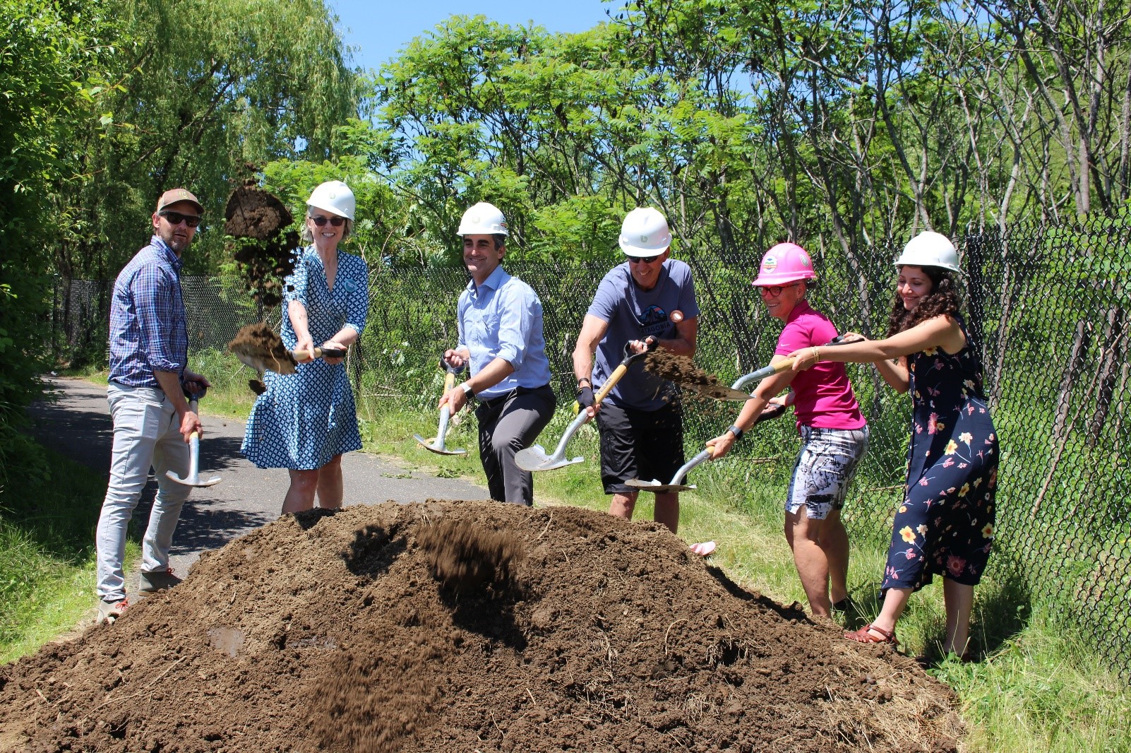
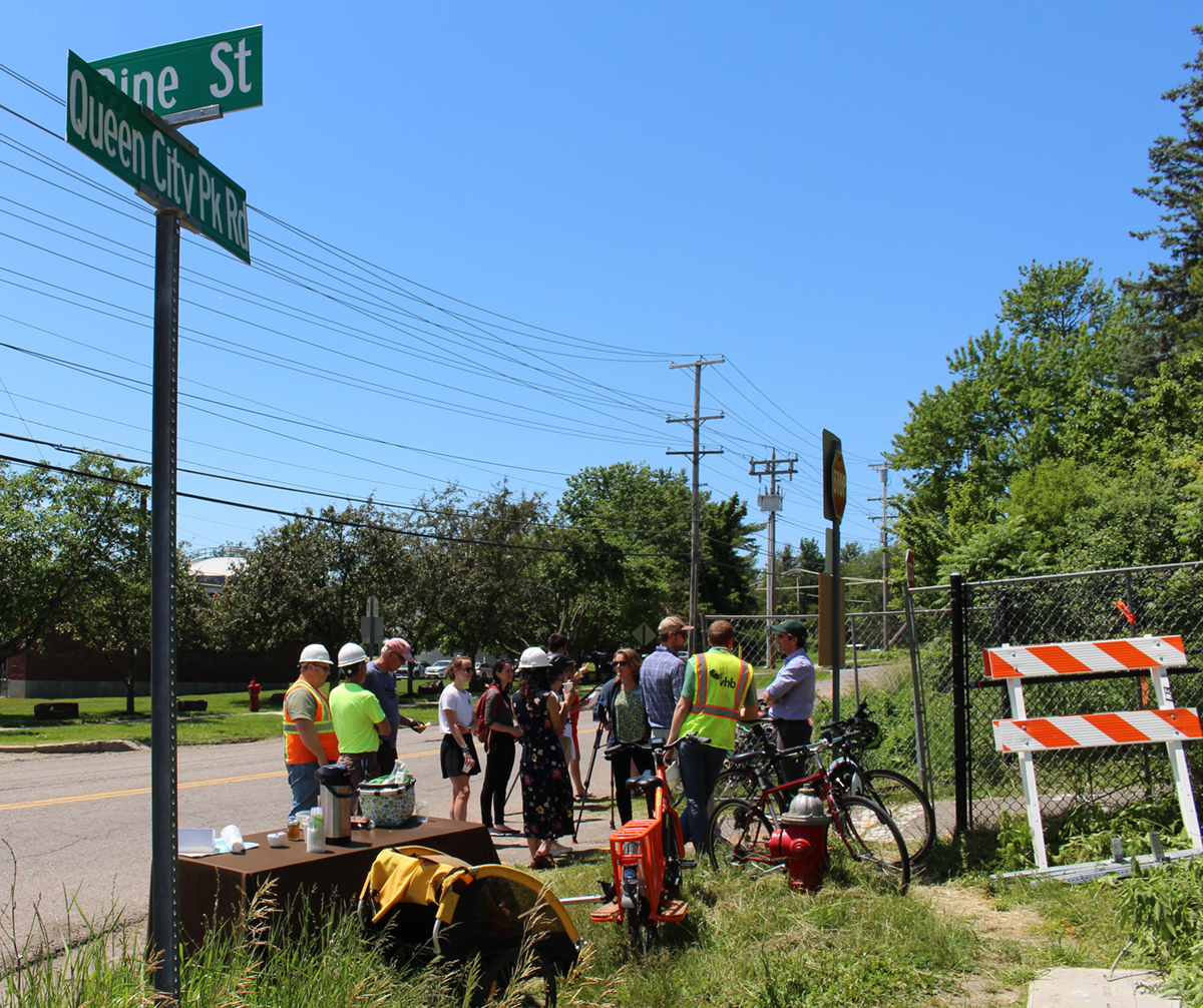
To celebrate the start of this season’s work, Mayor Miro Weinberger and Burlington Parks, Recreation & Waterfront held a press event on June 18 at the southernmost point of the path at Queen City Park Road we refer to as Segment Zero. Weinberger, South End City Councilor Joan Shannon, BPRW Director Cindi Wight and Parks Commission member and Burlington Parks Foundation founder John Bossange all spoke to the gathering of about 30 people, then grabbed shovels and hard hats and broke ground on this less know portion of the Greenway, aptly dubbed Segment 0. BPRW staff, Local Motion Director Karen Yacos, Bike Path pioneer Rick Sharpe, North Star Sports Manager J.P., State Representative Curt McCormack, along with the design engineer and contractor staff and members of the press gathered to celebrate the start of first piece of the south end portion of the Greenway. Special thanks for Local Motion for providing the electric assist cargo bike and Brio Coffee for donating drip coffee and cans of cold brew.
Rough grading has been completed on a 200’ section from Home Ave. southward. Initially the slope was 9%,but it’s now lowered to be under 5% and thus compliant with the American’s with Disabilities Act standards for accessible facilities. This will also make the path more visible and attractive to bikers and walkers, it will also prevent excessive ice buildup in the winter months, which had previously been a problem. This section will be completed by the end of July and reopened to the public. For now, it is closed to all users, with a suggested detour of either Industrial Ave. or Pine St. Expect all of the standard Greenway details: 11’ (in some cases 10’) asphalt paving with pavement markings, 2’ gravel shoulders on each side, concrete pads with detectable warning pads at all intersections and other current safety and accessibility standards. When completed, segment zero will connect with an already completed on-road section on Austin Drive, freshly paved with a combination of dedicated bike lanes or sharrows (shared-lane marking) depending on road width. Thanks to our friends at the Department of Public Works for completing this work under their annual paving contract. In the future, with the construction of the Champlain Parkway, and its accompanying multi use path, this area will be an important intersection for path users, with two multi use paths intersecting between the railroad corridor, the Parkway and Home Avenue.
The Schedule
Beginning in mid or late July, the contractor will leapfrog Oakledge Park (currently scheduled for reconstruction in 2020), landing on the near side of the Lakeside neighborhood, where they will formalize Proctor Place as a narrow residential street, connecting the existing path as it comes out of Oakledge Park at the bridge over Engelsby Brook. This will remedy the last of several undifferentiated street/path scenarios and make efficient use of a narrow residential street by sharing the road with path users. From there, the path heads east, continuing as an on-street facility for bicycles on Harrison Ave.. From mid-July through mid-August, the detour will bypass the construction zone via Flynn Avenue, Pine Street and Maple Street.
Late summer/early fall will see construction crews move to the Barge Canal, Roundhouse Point and Perkins Pier area. At that point, the Oakledge – Lakeside connection will have re-opened and the detour will push to the north, from Lakeside Avenue to Maple Street via Pine Street. Current schedules have the project substantially complete in mid to late November, with landscaping and other finishing touches installed the following spring.
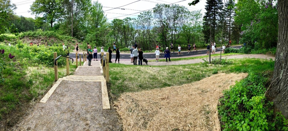
Work Continues at North Shore Pause Place
Work is progressing at the North Shore Pause Place, with concrete work, shoulder reconstruction and a portion of the landscaping completed ahead of the Vermont City Marathon in late May. Our contractor has recently returned to install low impact helical pilings that will hold the new steel and wood staircase connecting the Greenway with beach below. Being the first (and somewhat complex) installation of the new BPRW standard stair design, staff has been working to get the details right while emphasizing resilient design and use of local materials and in-state fabrication. BPRW expects Northshore to be fully complete in August. Stay tuned for further details as they become available.
June 17
Phase 3a of the Burlington Greenway Rehabilitation kicks off on Monday, June 17 in the section between Queen City Park Road and Home Avenue. The path will be closed to all traffic until completion, scheduled for mid-July. Industrial Avenue is the suggested detour. Please be advised of the closures and obey all detour signs.
BPRW’s contractor is building several sections of the southern portion of the Greenway between now and the end of the season in late November/early December. We are pleased to report that eachwill be built and reopened in separate phases to minimize disruption to bike path access during the busiest period of use. The schedule is as follows:
- Late June/Early July: Queen City Parkway to Home Avenue
- Mid-July to late July: Proctor Place/Harrison Avenue (Detour Flynn Avenue to Maple Street)
- Mid-August to November/December: Barge Canal and Roundhouse Point (Pause Place)
- Mid-October to November/December: Perkins Pier walkways
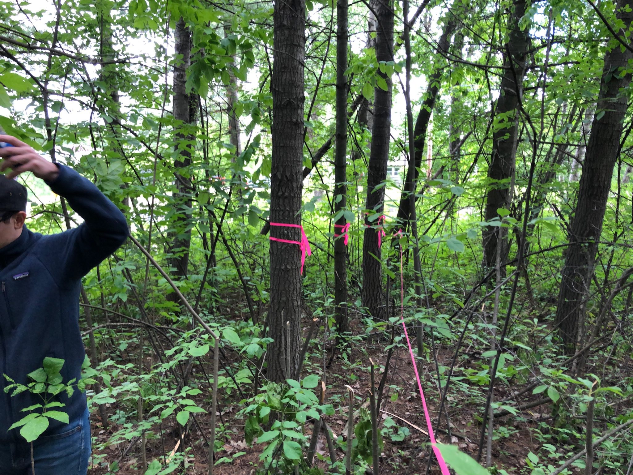
Treework
BPRW crews have marked trees to be saved in the Queen City Parkway to Home Avenue section with double pink tape and white spray paint. Please do not disturb any of these markings (a tree intended to be saved may be inadvertently removed). As on previous phases, BPRW has included a substantial replanting/landscaping component for this project. Additionally, BPRW will preemptively remove ash trees that will eventually succumb to the emerald ash borer and replant with a diverse selection of disease resistant and largely native species.
June Update
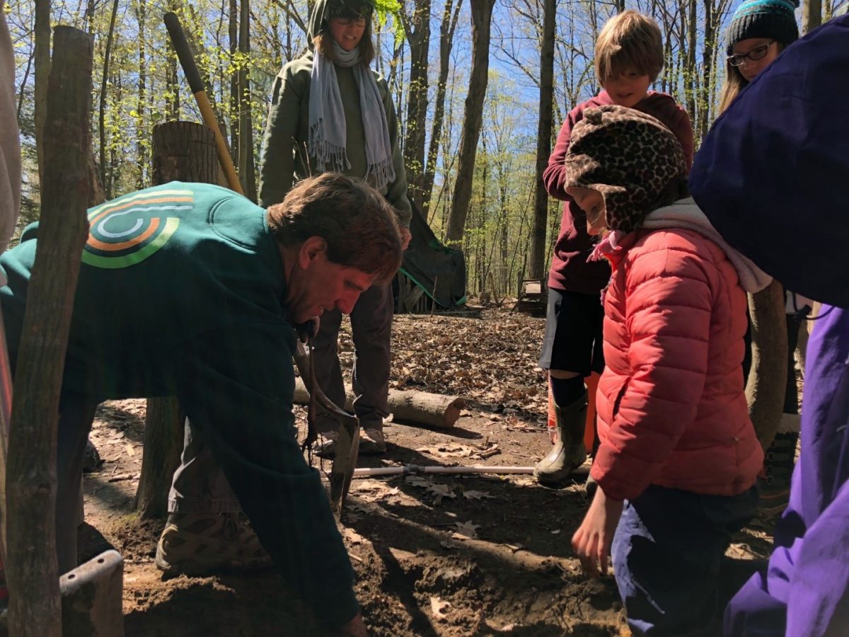
Archaeological work in Oakledge
Starting Friday, June 14, UVM’s Consulting Archaeology Program will begin doing some work, well in advance of any Path rehabilitation work in Oakledge Park. Because the park is known to have a long history of use, we’re taking the time to ensure that any artifacts are noted. They will be focusing on the new alignment by the Upper Pavilion parking lot and the new section that crosses to the Path north of the Upper Pavilion, as well as along the edge of the Path by the new playground.
This should not interfere with any park use.
April Update
Pause Places
Ahoy North Shore!
Leddy is Ready – For A Pause Place
Let’s Go to the Beach… Leddy Beach, that is!
University of Vermont Medical Center Fitness Station – Starr Farm
Burlington Greenway Rehabilitation Phase 3 – To the South!
TREES

Northshore Pause Place Takes Shape During Snowvember
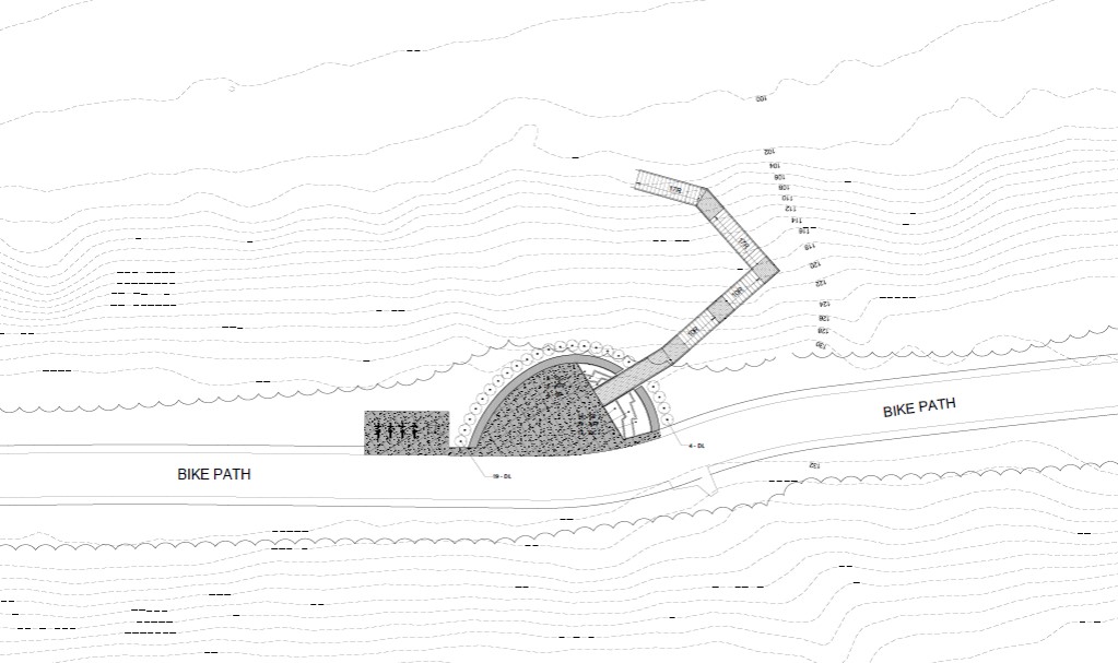
December 6, 2018 – The contractors worked through an unusually cold and snowy November to complete the basic structure of the Northshore Pause Place and Stair Access. They will return at the earliest opportunity in the spring to pour the exposed aggregate concrete paving that has become a signature on Greenway places to date (similar to the concrete walkway to access the beach near the oval overlook south of North Beach). Work will continue on installing helical pilings and pre-fabrication of the new Parks standard staircase.
The finishing touches at this newest and northernmost overlook will include bike racks and Big Belly solar powered garbage and recycling containers. Additionally, there will be a commemorative bench, donated by our Greenway partner, Local Motion, on behalf of one of their members. We would like to thank the Burlington Parks Foundation for their continued support for Greenway rehabilitation. This time out, generous donors provided $100,000 towards construction of this substantial upgrade. Stay tuned for spring construction details and an opening celebration.
North Shore Pause Place Reconstruction Begins!
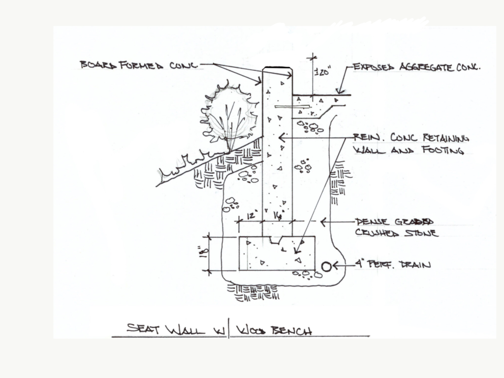
October 17, 2018 – The North Shore Pause Place installation kicks off later this week with demolition of the existing damaged stairs and the remainder of the wood and brick structure. The new designs will have the same functions of a wayside gathering and scenic viewing spot with stair access to the beach, but with noticeable improvements. The new pause place will be built to last featuring textured concrete overlook seat walls, a memorial bench supported by a Local Motion donation, separate bike parking and recycling/trash receptacles (BPRW’s highly successful Big Belly solar powered compacting smart waste and recycling containers), native and naturalized plantings.
The project will debut BPRW’s new standard staircase design, featuring galvanized/powder coated steel with replaceable wood treads and risers. This system can be custom ordered based on site needs and installed with a crane as a prefabricated unit. Additionally, the staircase will be supported by helical anchors. The helical anchors are BPRW favorite for their efficiency and minimal disturbance, special drill-in-place footings that utilize no excavation, no concrete, no extra material to remove, and no backfilling.
Weather permitting, the new pause place is expected to be completed by mid-December with the staircase installation later in the winter to minimize disturbance.
Burlington Greenway users, the path should remain open for most of the construction period. There may be some short term closures – stay tuned here for details. Please use caution as you approach this work zone, located between Starr Farm Road and North Ave Extension. This project is supported by charitable donations via the Burlington Parks Foundation in addition through the Penny for Parks dedicated tax program.
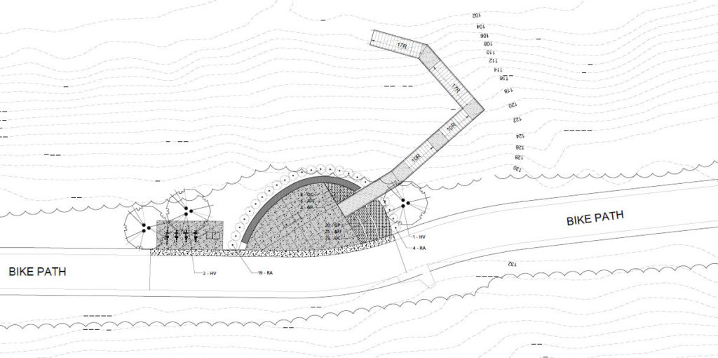
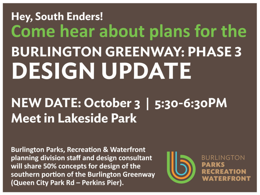
Public Presentation on October 3rd
Meet us in Lakeside Park to hear all about the plans for the final phase of Burlington Greenway (Bike Path) Rehabilitation project.
Burlington Parks, Recreation & Waterfront planning division staff and design consultant will share concepts for design of the southern portion of the Burlington Greenway (Queen City Park Rd – Perkins Pier).
Phase 3 Design Kicks Off
The third and final phase of the Burlington Greenway has kicked off, with BPRW contracting with VHB, a South Burlington engineering firm that has provided design services for phases 1 and 2 previously. Phase 3 begins at the City’s southern border (Queen City Park Road), parallels the Champlain Parkway alignment, connecting to Oakledge Park via Austin Drive, through the Lakeside neighborhood, behind the former Blodgett Oven factory, then passing through Roundhouse Park and Perkins Pier.
Design development will follow the 2013 Conceptual Design, developed for the entirety of the 8+ miles of waterfront bike path in the Burlington city limits. Extensive public engagement happened during that process, with input from various stakeholders, neighbors and bike path users shaping this conceptual alignment and design. BPRW will be making informational stops at the Ward 5 NPA later in the fall to update the public on the project.
BPRW is looking forward to completing this last portion of this immensely popular recreational and transportation facility. Additionally, in keeping with the approach on Phases 1 and 2, the project will include additional pause places (Oakledge and Roundhouse Parks) and UVM Medical Center Fitness Stations (Oakledge). Of course, during construction there will be detours and closures. Please monitor our communications for the latest updates. We thank you in advance for your continued patience.
Phase 2: Smooth Sailing and Pause Places
We hope you have enjoyed a season of unimpeded access to the newer portions of the world class Burlington Greenway. BPRW opened a completed phase 2, from North Beach Campground to the Winooski River, in time for the Vermont City Marathon at the end of May, 2018. We were thrilled with the enthusiasm both the event organizers and spectators embraced new facilities and access points. The new parking area at North Avenue extension functioned beautifully as a watering and bathroom station, and the new access point at Killarney Drive was a veritable park with large crowds gathering to watch this central location. Since the Marathon then the grass has fully grown in!
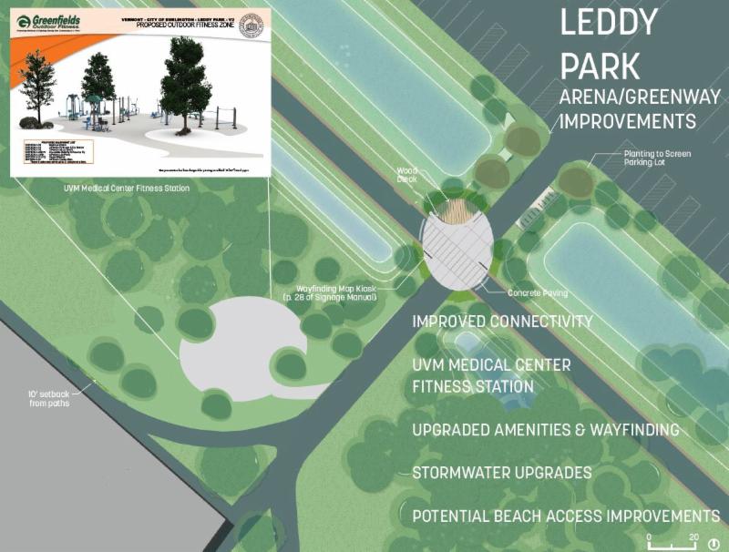
Completed on time, with minimal complications from working with urban soils, the 3.3 mile, $2.6 million dollar Phase 2 Burlington Greenway Rehabilitation marks the successful completion of the largest BPRW managed project to date. While the path proper has been open for months, Pause places are designed and ready for fall construction at Leddy Park (near the Arena) and Northshore, and a third slated for construction next season at Starr Farm Park. Leddy Park will not only see a new oval pause place with decked overlook at the intersection of the bike path and the entrance to the Arena, but will also include accessibility upgrades between the bike path, Arena front entrance and Leddy Beach, improved stormwater management and the replacement of wood stairs between the Picnic Grove and the beach.
The University of Vermont Medical Center Fitness Trail will add to the growing network of Exercise stations with their fourth location created between the Greenway and the entrance to the arena. BPRW Director and Planning Staff presented these plans and projected construction schedule at the Wards 4/7 Neighborhood Planning Assembly on August 22, 2018.
Northshore will see a replacement of an overlook that was built in the 1990’s that will include an exposed aggregate plaza, bike parking, a bench plus seating wall, native plantings and the replacement of steps to the beach that were destroyed by fire last year. BPRW is working closely with the State of Vermont Department of Fish & Wildlife on the preservation of the fragile ecosystem. While given the all clear for replacing the pause place and staircase at the northern North Shore location, State botanists will play a planning role in any future construction in the stretch between Starr Farm Park and North Avenue.
BPRW is in the midst of gathering public input and studying existing park use at Starr Farm in preparation for hiring a design consultant for the creation of the final New North End pause place, complete with a University of Vermont Medical Center Fitness Station. Please weigh in by taking the Starr Farm survey! We’ll let you know when it’s available via this home page, Front Porch Forum and our facebook page.
Our Trees & Greenways team, in collaboration with our Parks Planning Division, are preparing for the first phase of an ambitious tree planting in the Phase 2 corridor. Using research proven planting methods and timing, BPRW will plant 120 trees in October. More recently, BPRW staff members paid a fireside visit to the Crow’s Path Outdoor School at Rock Point to talk trees and deliver and plant special gifts: bare root bur oaks and bitternut hickories that were then sighted, planted and mulched with the children. Over the summer, the students have been watering these plantings and monitoring their success.
Finally, the last piece of the northern Burlington Greenway remaining is the replacement of the North Beach overpass, connecting North Beach Campground and North Beach. Construction drawings for that structure are currently being wrapped up, with construction scheduled for winter and spring of 2018-19. This project will greatly enhance safety, accessibility, ecology and aesthetics at the important intersection, and BPRW and their designers are working closely with the State of Vermont Agency of Transportation, which owns this section of the Greenway right-of-way.
I received an “out of office” response to DM Wood to my following question:
“Dear DM Wood,
I’ll be out of town on the 3rd, and would like to know if the “Amtrak Realignment” will include removing the two railroad tracks crossings from the path? I’ve been a supporter of working with Mr. Pecor to provide easement (or sale) of that portion of his Ferry property that would allow the Greenway to avoid those two dangerous (to bike wheels, etc) crossings and the horrible bottleneck at the Wing Building.”
The focus of Wednesday’s meeting will be on the Greenway/Bike Path Rehabilitation in the South End. The King to College section is a separate project. Our team is looking into the feasibility of realigning the bike path to the western side of the tracks as well as a few different width alternatives for realignment. We have heard from other Burlingtonians like yourself who also support a realignment. We’ll share updates on the Greenway website as they are available.
Hi, will we be adding lights as part of the phase 3 redesign?
Hi Damon, lighting along the path is not part of our standard design, unless the path travel through a park or traffic intersection.
With regard to the 7/19 update on Segment Zero: You must have an interesting definition for the word “completed.” It certainly doesn’t mean “open,” as when I arrived at the Queen City Parkway entrance on my way home that evening from work by bike I was greeted by a large “CLOSED” sign and a chain link fence stretched across the entrance. At least, however, that side looked fully paved. I decided to inspect the Home Avenue entrance, which was not only closed and fenced off, but the entrance and connecting sidewalks were still bulky gravel, and a backhoe was straddling the sidewalk area. Now, my fat bike would not have much difficulty with it, but I doubt many bicyclists would like to ride across that. So I presume that this work still needs to be “completed,” or do you have another word for it in your vocabulary?
Good point, Jim.I’ll edit that section to be more forward looking. Work still needs to be completed. -Diana
Thanks, Diana. I’d like to also make a suggestion with regard to the detour routes being advised by BPRW for the upcoming work on Proctor Place/Harrison Avenue. From my understanding of the description of work to be done, while Proctor Place will receive the full sub-base “treatment” (it certainly needs it), the improvements to Harrison Avenue, should mostly consist of markings and wayfinding. If that is the case, it seems to me that the railroad crossing from Sears Lane should be able to be kept open, at least for most of the work, and be available as an alternate route for both bicyclists and pedestrians to enter/exit the Greenway. Even if this is not the case, the stairs next to Hula (old Blodgett property) off of Lakeside Avenue would also offer able-bodied pedestrians the opportunity to leave/rejoin the path. I offer these suggestions because many bicyclists are not comfortable riding on Pine Street, particularly northbound, where there are no substantial facilities between Locust and Maple streets (sharrows only). Between Howard and Maple the road is almost always narrowed by parking, and the same is true between Locust and Howard during the day, when Dealer/Cox’s workforce is present. Even I, who would generally be classified as a “Class A” bicyclist, that is “confident and assertive,” don’t particularly enjoy riding down this street during periods of high traffic volume. And I’m sure most pedestrians out for an enjoyable walk along the waterfront don’t wish to divert from it for over a mile. Cutting the diversion down to the distance between Sears and Flynn Avenues lessens the impact of the Proctor Place/Harrison Avenue work greatly. Thanks.
Thanks for the suggestions about the detour routes. Our suggested detour routes are proposed using defined roadways, preferably with bike lanes and markings. I believe this is standard practice for official construction detours statewide. We figure that Greenway users familiar with the areas will discover their own preferred route.
So it’s now August 13th, and Segment Zero is still closed. What’s up? The only thing that seemed to remain was the sidewalk/entrance treatment at Home Avenue. Also, Proctor Place/Harrison Avenue remain open. I assume that is because there is only one contracted crew working on these phases and they haven’t moved to this segment because they haven’t finished Segment Zero yet. Don’t get me wrong. I’m happy Proctor Place is still open and that more people can use the path more fully during the summer weather. However, many people use the path for transportation, errands, etc., and knowing what is open and what is not is important for planning purposes. This is especially true given the work that has been ongoing on lower Pine Street this summer. Thanks for your consideration.
Now on top of all your other junk development, there is a huge parking lot right on the beach past the railway.
Thanks to You Burlington Parks and Rec for Fouling up our Waterfront And City.
Can you clarify the location you’re referring to? That might not be a parks project or even a City project.