Finding Burlington’s Past in Redstone Quarry

It can be hard to find Redstone Quarry. It can also be hard to explain why you’d want to. I’ll try to help with both.
You’ll find Redstone Quarry at the end of Hoover Street, just off Shelburne Road in Burlington’s south end. At the end of Hoover, you’ll turn right onto the unpaved Redstone Terrace. Looking east, the quarry will be all in front of you, though it may be hard to see past a row of trees and hedges. You will go to a giant, droopy willow—a sign’s nailed to the trunk of the tree: “University of Vermont Natural Areas; Designated For Educational and Scientific Purposes.” Behind the willow, you’ll find a clear path to take you in.
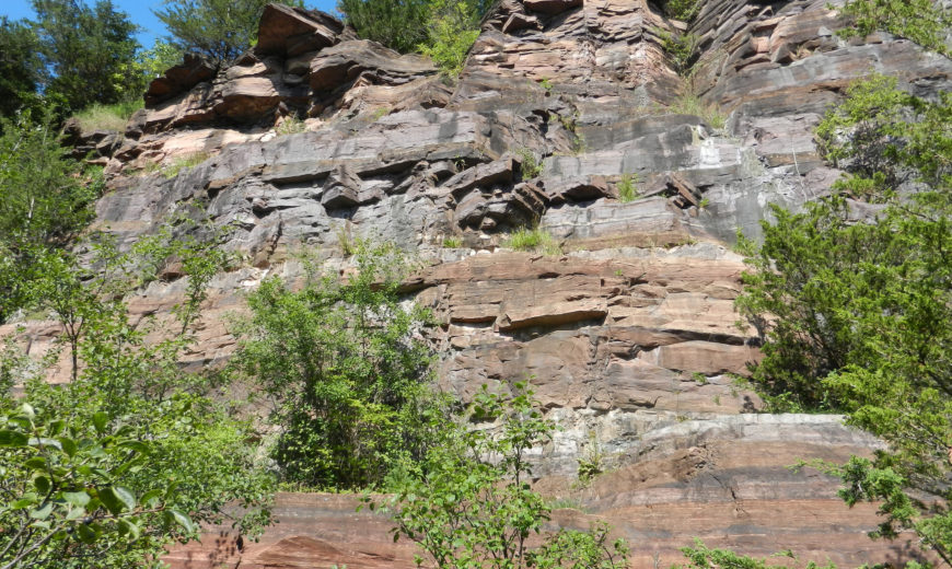
The quarry wall is around fifty feet at its tallest. It’s startling to see such a complete break in the continuity of Burlington. Running across the top of the rock wall is the backyard fence of a house that sits above, and the distance between the neighborhood below and the neighborhood above feels uncannily far. The natural area is a narrow corridor that extends north and south along the quarry wall. Walking south down the path, the quarry turns into a wetland. A green sheet of duckweed lies on top of the water, and cattails line the path. When I visited the quarry, a pair of black crowned night herons roosted on a low branch over the green water, hunkered down during the bright day.
Walking north, the quarry opens up on long shelves and wide floors of stone. Patches of tiny wildflowers crawl over the rock surface, and grass sticks out of cracks and corners. It can be difficult to tell when the quarry—the protected natural area, owned by the University of Vermont and open to the public—ends. You may wander perilously close to someone’s backyard, and a rock painted with “PRIVATE” will help you know when to turn around.
The rock here, the so-called ‘redstone,’ is more precisely known as Monkton Quartzite. If you get your face up close to the rock, you’ll see the shimmer of quartz grains cemented together. Iron oxide is in the mix, giving the rock that reddish hue. From further away, you’ll get a sense of the layers of this sedimentary rock and imagine the intense compaction that pressed the sediment into stone.
It’s common for geologists to characterize an educational excursion to look at and think about rocks as a sort of “trip through time.” To see the wall of Monkton Quartzite, for example, could be an invitation to consider the conditions of the Cambrian Period, around five hundred million years ago. The quarry offers this dimension of time travel: you can look into the redstone, and imagine the deep past of Burlington’s bedrock.
But this quarry down at the end of Hoover Street is a gateway to another time and dimension, too. To enter this portal to the past, you must look at the redstone, rather than into it. To get there, you must ask questions: Why is this rock face exposed? What does it mean that there is a fifty-foot cliff separating Hoover Street below from Crescent Road above? Where have I seen this stone before?
Besides the Cambrian Period, Redstone Quarry also whispers back into the last century and a half of Burlington’s history. From the quarry, you can see Burlington becoming a city—the second half of the nineteenth century was an intense period of growth, urbanization, and construction. Lumber from up north flowed into Burlington Bay to be milled and shipped south, while wool mills on the Winooski River processed textiles and Champlain Valley dairies produced more and more butter and cheese.
With the rest of the country, Burlington was growing, straining, and splitting. In 1860, the pressure of a too-large membership in the First Calvinistic Congregational Church—and internal disagreement about the most righteous approach to abolition—forced the creation of a new congregational society in Burlington. This new society erected the College Street Congregational Church in 1863. To build the new church, they pulled yellowish sandstone from this quarry, then called Willard’s Ledge.
The workers who made Burlington’s big industries run lived beside the lake in the city’s south end, level with Willard’s Ledge. Those who got rich off Burlington’s industries, like the lumber baron Andrew Addison Buell, built their estates up on the hill. Buell sourced the Monkton Quartzite for his house from Willard’s Ledge in 1889. After the Buell family passed their estate to the University of Vermont in the early 1900s, their buildings housed some of the university’s first female students. Buell’s estate is today’s Redstone Campus.
Redstone Quarry is a special kind of wild. Many of Burlington’s green spaces, like Ethan Allen and Oakledge Parks, have long been set aside and designated as pleasant, natural places. In the quarry, looking at the redstone wall, you’ll be face to face with a piece of Burlington that was never supposed to be beautiful. Now, it’s where the night herons go to find some quiet.
Written by Will Lathrop
Feature photo by Sean Beckett
Works Referenced:
- Burlington: A History to Vermont’s Queen City, Vincent E. Feeney, 2015.
- Burlington Geographic, http://www.uvm.edu/place/burlingtongeographic/index.html.
- Historic Guide to Burlington’s Neighborhoods, Vol. II, Chittenden County Historical Society, 1997.
- “Roger Allbee: When Vermont was the butter and cheese capital,” VT Digger, https://vtdigger.org/2018/08/26/roger-allbee-vermont-butter-cheese-capital/.
- “Vermont State Rocks,” Department of Environmental Conservation. http://dec.vermont.gov/geological-survey/vermont-geology/staterx.
