Arthur Park
Burlington writer Levi Smith wrote beautifully of Arthur Park’s environs in 1907:
“In few places does nature reveal herself in so many and such diverse aspects as here at the Devil’s Den. On the one hand a sense of grandeur, a great cave which stretches back into darkness spanned by massive vaults and arches of weather beaten rock which ascend in unbroken curves and cast dark shadows and reflections in the water at their base… The approach to the Devil’s Den, although at certain times of the year a bit boggy and difficult is not entirely without charm. These are the haunts of the swamp sparrow and hermit thrush. On one side there is always the view and the luxuriant marsh foliage, while on the other are high rocks festooned with thick hanging masses of nightshade, as deadly as it is beautiful. Here are found the rarest ferns. But perhaps the greatest charm of this place lies in its seclusion. It is to all appearances as unfrequented and remote from the world as if it were situated in the wilds of Africa [1].”
Little has changed in the intervening century since Smith described the area. Inconspicuously tucked into the hillside across North Avenue from Burlington High School, Arthur Park is a small forested oasis spanning the hill between the North End plateau and the fertile Intervale lowlands below. At a surprising 70 acres, the park is a literal cross-section of Burlington’s natural and cultural history, and accesses a nearby ancient cavern known for generations as the “Devil’s Den” or “Intervale Sea Caves.”
An Old Road
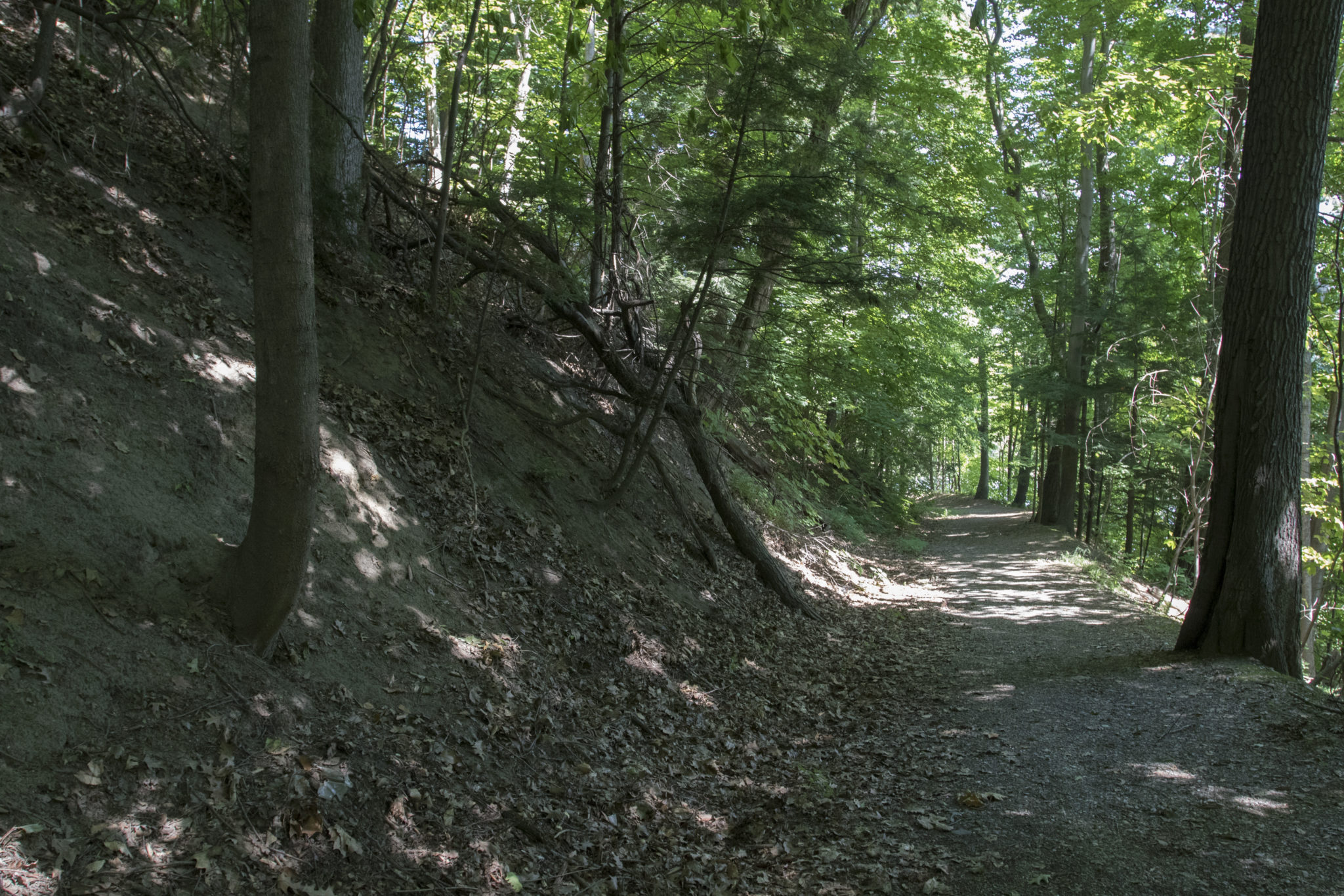
The main pathway at Arthur Park is a dirt road, lined by old, stately oaks that runs downhill from the congested traffic of North Avenue, terminating at a secluded pond and cattail marsh. Old photos and oral histories reveal that this old road once connected North Avenue all the way to the Winooski River prior to Route 127’s construction [2,3]. Local farmers used this road in the 19th and early 20th centuries to access the intervale farmlands from their evening pastures and farmhouses along North Avenue. For four decades beginning in the 1920s, Willard Arms would drive his Intervale Jersey Farm cattle each day from his farm where Burlington High School stands today, across North Avenue (much to the chagrin of motorists and trolley cars), and down this old road [4].
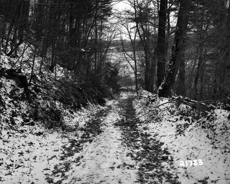
When cattle traffic waned in the winter, North End children congregated to race toboggans down the dirt roadway on snow-filled wooden chutes purportedly built by the City of Burlington. At the bottom of the hill, large jumps rocketed the children and their sleds into the air and across the frozen pond and farmlands. A good run coasted the toboggans all the way to where Route 127 now bisects the fields. The tracks were installed in honor of the 1932 Lake Placid Olympics and the U.S. bobsled team [5]. To the dismay of the local kids, the toboggan chutes accidentally went up in flames during a routine vegetation burn along North Avenue [6].
Listen to Burlington resident Charlie Auer tell the story of an old toboggan track running the length of the old roadway in the 1930s.
A New Pond
The Intervale farmlands sit in the Winooski River floodplain, where annual spring floods historically drenched the entire lowland beneath North Avenue. Old residents recall paddling their hunting boats from the river channel out across the flooded fields in search of migratory waterfowl each spring. By summer these waters receded, depositing the rich sediment that produces the area’s unparalleled soil fertility [4].
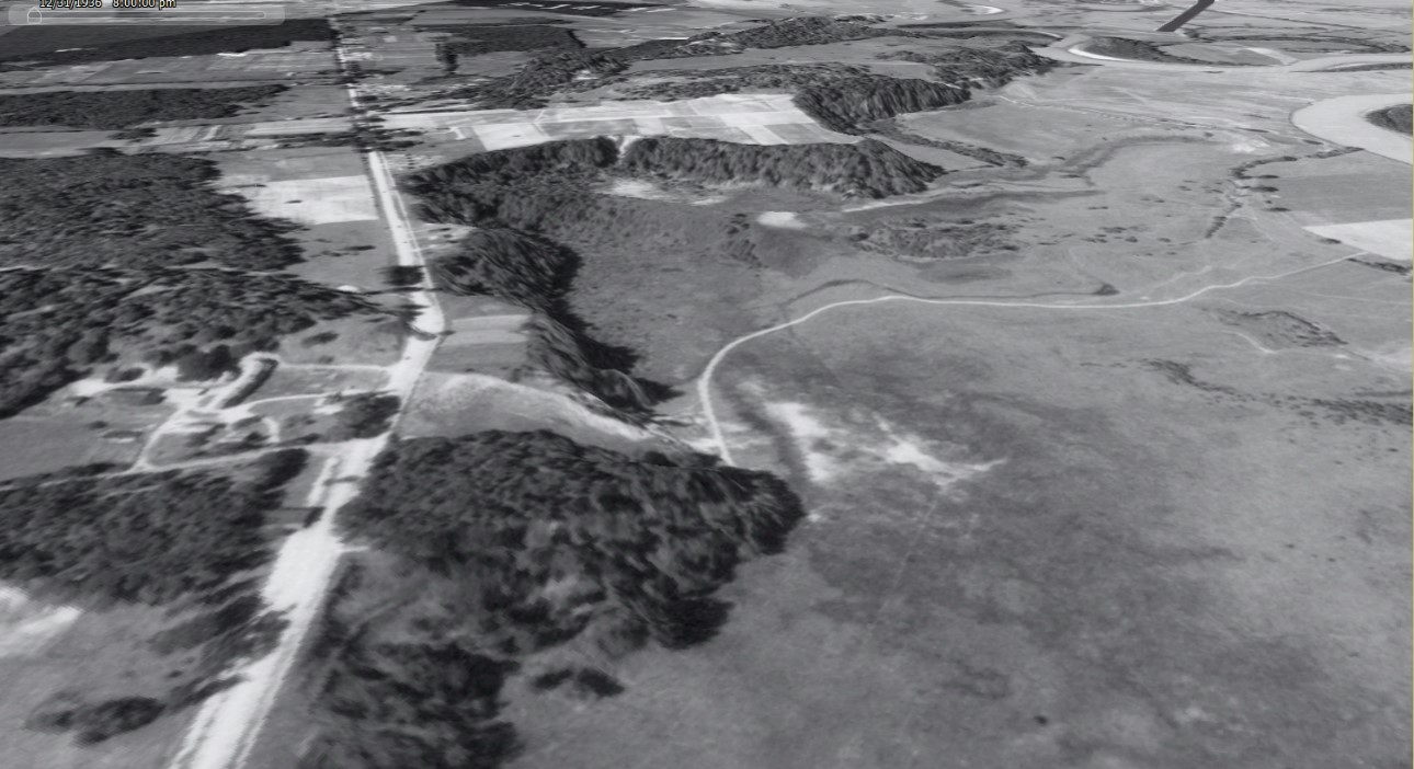
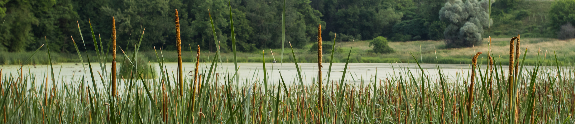
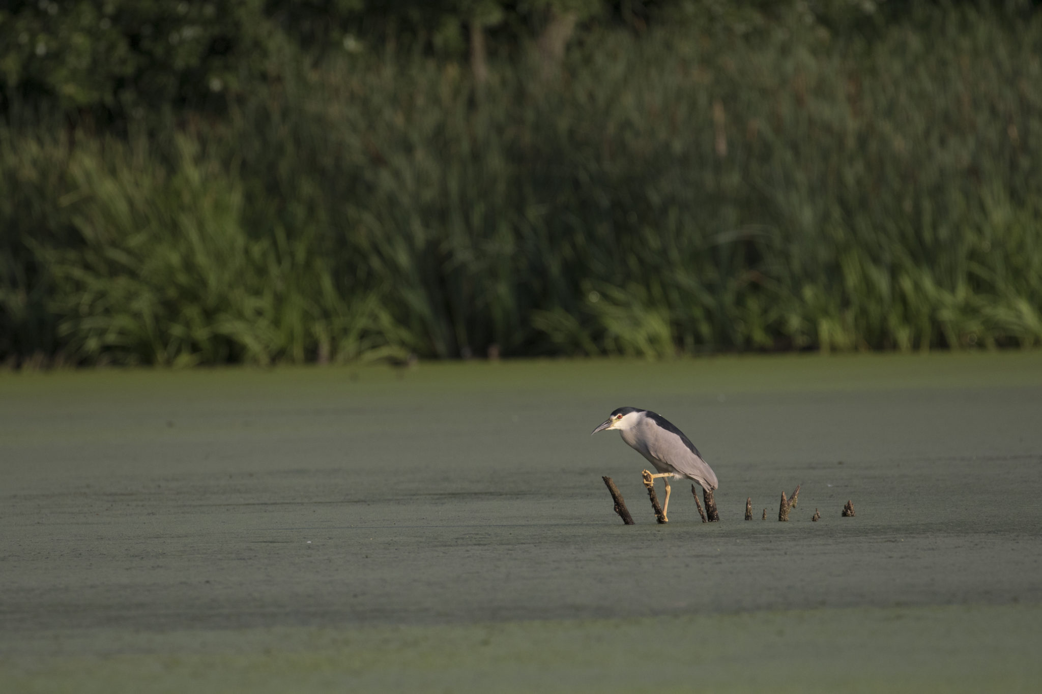
But the creation and expansion of the old floodplain road into today’s Route 127 severed the flow of water across this lowland, and the trapped hydrology soon yielded a wetland sandwiched between the base of the hillside and the highway [3,4]. Known as Long Pond by kids growing up in the 1940s, this is the pond where visitors of Arthur Park today can find elusive black-crowned night herons, basking painted turtles, and warbling marsh wrens.
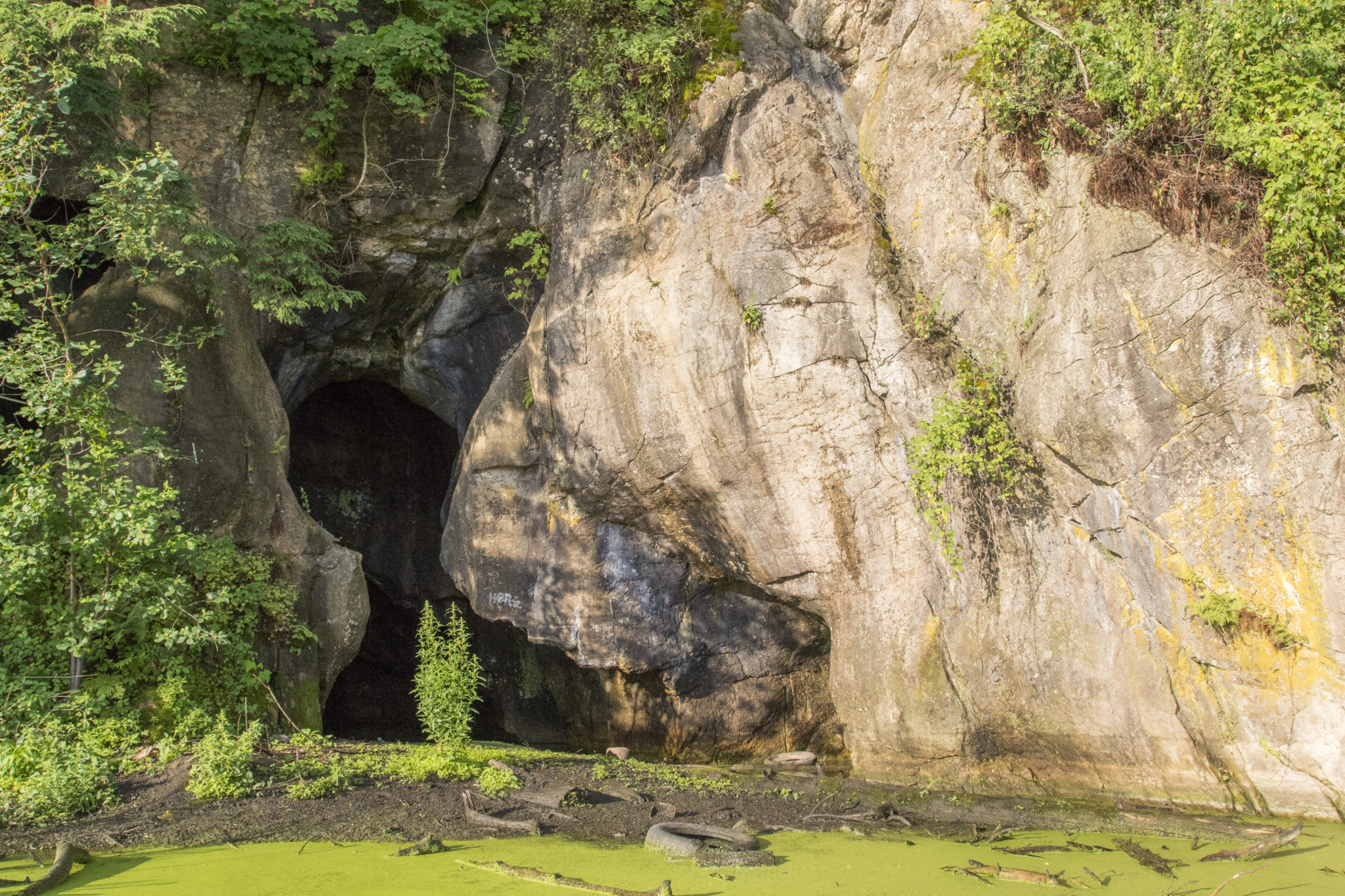
An Ancient Cave
Arthur Park provides direct access to one of Burlington’s most unique natural features: The Intervale Sea Caves. Visitors could once stroll right up to the cavern in dry summers, but the pond today requires explorers don ice skates and visit in winter. Once inside, explorers will look down to find schools of fish swimming beneath the clear ice, or look up to enjoy a palette of rose, ochre, and red rocks polished by millennia of waters and winds.
For thousands of years, Native American communities farming, fishing, and inhabiting the Winooski River’s Intervale took advantage of the Sea Caves’ natural shelter. The moderating temperatures and protection from the prevailing wind made the site a perfect meeting location and storehouse. In the winter, families congregated in the caves to find a warm retreat from the season’s most bitter temperatures. In the summer, the caves were a favored storehouse for goods like dried fish and corn, critical commodities traded by the local Winooskiok Abenaki community [7].

More recently, the caves inspired myths of buried treasure. Legend suggests that the crew of the notorious Black Snake smuggling vessel stashed their stolen wares in the Sea Caves during their flight up the Winooski River in 1808. Their pursuers, U.S. Customs militiamen, caught up with the Snake and apprehended the smugglers shortly thereafter [8]. Treasure hunters would be tempted to search for the riches until learning that the Snake carried a rather inauspicious cargo of potash.
The caves are the product of two ancient salt water bodies. Long before the dinosaurs, Burlington sat quietly under the tropical, shallow Iapetus Ocean, collecting sand, silt, volcanic ash, and dissolved marine life percolating to the seafloor over 200 million years. The sediment congealed and hardened under the weight of the water and the forces of time into the beige limestones (locally known as dolostone) seen across northern Burlington today.
Fast forward to the end of the last ice age, 11,000 years ago, when the entire Champlain Valley was inundated by another warm and shallow water body, the Champlain Sea. Resting 100 feet higher than today’s Lake Champlain, the Champlain Sea intercepted the Winooski River much farther upstream than its current mouth. This larger, ice-age Winooski River deposited enormous quantities of sand and silt into a giant, flat delta situated over much of South Burlington, Burlington, and Colchester, draping yards of sediment over the landscape.
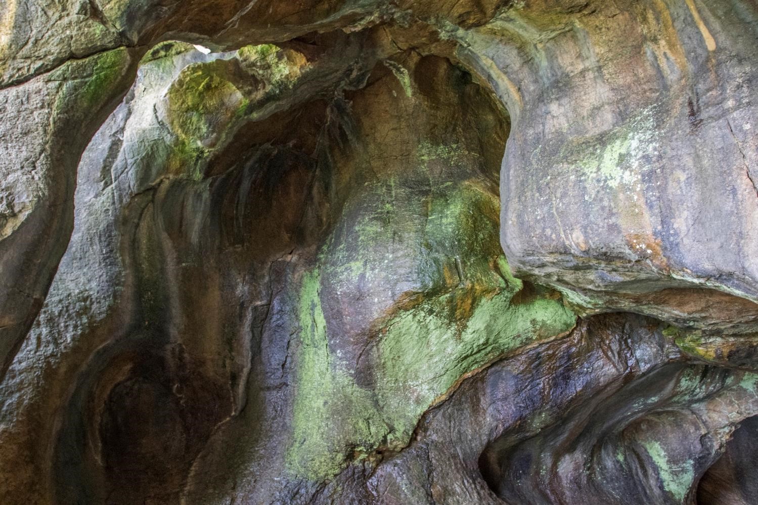
The Champlain Sea receded to our present lake level, and the modern Winooski River narrowed, carving down through its former delta like a knife through butter, settling into its current floodplain. As the Winooski meandered over millennia, the river channel periodically hugged the Arthur Park hillside, excavating down through old the delta sands, exposing the dolostone beneath, and polishing out the pre-existing cracks and fissures into the wide, smooth Sea Caves we see today.
Leaving the Sea Caves and proceeding back up the pathway, the explorer traverses a veritable timeline of Burlington’s history. He starts beside the showpiece of Burlington’s bedrock origins, continues uphill past a cross-section of ancient delta sand, walks atop the abandoned access road to the colonial Intervale farms, parallels an old toboggan slide, and emerges alongside 21st century-Burlington’s main traffic artery between downtown and the New North End.
Written and compiled by Sean Beckett and Samantha Ford in partnership with Burlington Geographic. Contact PLACE@uvm.edu with questions and inquiries related to this research.
Reference:
- Blow, David. Historic Guide to Burlington Neighborhoods. Chittenden County Historical Society, 1991.
- Sanborn Fire Insurance Co. 1937. Aerial Orthophoto. Available at http://www.uvm.edu/place/burlingtongeographic/maps/index.php
- Wiedenmayer, Donald and Joe Frank. Road near North Ave, 1969. Negative 21782. Vermont State Archives and Records Administration. Available through the Landscape Change Program: www.uvm.edu/landscape/menu.php
- Intervale Center, The. The Old Intervale. Kenneth Peck Studios, 2003.
- Richard Kieslich, Personal Communication, August 2016.
- Charlie Auer, Personal Communication, July 2016.
- Charles L. Delaney, Personal Communication, July 2016.
- Arms, David. “My Intervale Farm.” Vermont Life Magazine, 1951. Available at Special Collections, UVM Bailey/Howe Library.